 Route Editor

| Guide | ♦ | 14 Triplogs | 1 Topic |
details | drive | permit | forecast | 🔥 route |
stats |
photos | triplogs | topic | location |
| 0 | 14 | 1 |
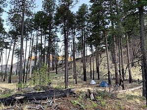
 Good views of Cave Creek Canyon make this trail an excellent way to get acquainted with the cliffs, caves, pinnacles, and peaks that give this scenic valley its unique character. The trail leaves the main road in Cave Creek Canyon, at a trailhead that is convenient to all the campgrounds located there. It then follows Snowshed Ridge, an ascent that is relatively moderate in its initial stretches, as it climbs toward the Chiricahua high country. The views start right from the trailhead and continue all along the route making this trail a good one to follow even if you don't have the inclination to traverse all of its 10.1 miles. Good views of Cave Creek Canyon make this trail an excellent way to get acquainted with the cliffs, caves, pinnacles, and peaks that give this scenic valley its unique character. The trail leaves the main road in Cave Creek Canyon, at a trailhead that is convenient to all the campgrounds located there. It then follows Snowshed Ridge, an ascent that is relatively moderate in its initial stretches, as it climbs toward the Chiricahua high country. The views start right from the trailhead and continue all along the route making this trail a good one to follow even if you don't have the inclination to traverse all of its 10.1 miles.As Snowshed Trail nears the peak for which it is named, the gradient steepens and trailside vegetation changes from pinyon, oak, and madrone to more high country species such as ponderosa pine and aspen. About a half-mile beyond Deer Spring is a trail junction that presents three alternative routes. Turning to the right (northeast) takes you to Snowshed Peak along a course that offers better views than the summit itself. On the slopes of Snowshed Peak, switchbacks are the rule as the trail traverses old talus slides presenting birds-eye views of Cave Creek Canyon and its South Fork. Continuing straight at the junction takes you west to the Crest Trail #270A in the direction of Chiricahua Peak, and turning left heads you south to Juniper Spring. Check out the Official Route and Triplogs. Note This is a difficult hike. Arrive fit and prepared or this could get ugly. Leave No Trace and +Add a Triplog after your hike to support this local community. One-Way Notice This hike is listed as One-Way. When hiking several trails on a single "hike", log it with a generic name that describes the hike. Then link the trails traveled, check out the example. | |||||||||||||||||||||||||||||||||||||||||||||||||||||||||||||||||||||||||||||||||||||||||||||||||||||||||||||||||||||||||||||||||||||||||||||||||||||||||||||||||||||||||||||||||||||||||||||||||||||||||


