| Guide | ♦ | 3 Triplogs | 0 Topics |
details | drive | permit | forecast | route |
stats |
photos | triplogs | topics | location |
| 9 | 3 | 0 |
I Like Big Loops and I Can Not Lie by AZOutdoorsman  Warning WarningSections of the Ford Trail are in a canyon drainage - sandy bottom & rock scrambling. Overview A true trailed loop of 19 miles combining multiple trails (well signed/marked) in White Tank Mountain Park. "I Like Big Loops and I Can Not Lie" - Sir-Hikes-a-Lot. I know there are others on the site who feel as I do. I put this one together, combining multiple trails to form a true, trailed, big loop out on the westside!
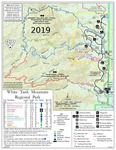
I started at Picnic Area 2 (see map) and did the loop clockwise, preferring the steepest ascent on a good trail at the start, then coming down the sandy drainage of Ford. As you can see from the map, there are several areas from which you could start the loop and go in either direction. I'm a pretty fast hiker and did some light/intermittent jogging on some of the easier sections - your time will, of course, vary from mine. Heading out on the Bajada Trail (0:00 time), I soon rolled into the Goat Canyon Trail. This a great training ascent on pretty good trail tread (as are most of the trails). After about 6 miles I took the turn onto Mesquite Canyon Trail (2:08). (If you are looking to cut a few miles/100s' of AEC, you could continue onto Ford Trail at this point and eliminate the "horseshoe" section of this loop). Heading down a couple miles and crossing Mesquite Canyon onto the Willow Canyon Trail (2:56, includes:10 break). Now heading up and just before leaving Willow Canyon, there is a little side-route to the seasonal falls (out-and-back of just a few yards). Back on the trail to the junction with Ford Canyon Trail (3:36). I continue right on Ford Trail, which eventually goes into the canyon. Now the "trail" is through the drainage for a couple of miles or so. I pass the old dam and several cool bedrock areas that I scramble over - nothing too difficult for those used to off-trail. (Don't miss the stick sign with double right arrows at the canyon exit). Eventually, back on the lower part of the mountain, I reached the junction with Waddell Trail (5:57, includes:30 break). Following Waddell for about a mile, I reach Mesquite Canyon Trail once again and take a left. After about a mile, it dumps me into a parking lot. I walk to the opposite side and find the sign for the Mule Deer Trail (6:25). This trail goes through a burn but is still well-defined. After about a mile on Mule Deer I come to the junction with Bajada Trail (6:48) and take a right. In less than a mile, I'm back at the truck and have completed this loop! Finished 6h 58m. Synopsis A nice loop with some great scenery just outside the valley! All the trails are in excellent shape and well marked. I didn't GPS the route. Have Fun!!! Check out the Official Route and Triplogs. Note This is a more difficult hike. It would be unwise to attempt this without prior experience hiking. Leave No Trace and +Add a Triplog after your hike to support this local community. | |||||||||||||||||||||||||||||||||||||||||||||||||||||||||||||||||||||||||||||||
 Route Editor


