Overview
Fairly easy trail in the heart of the White Tank Mountains that can be incorporated into a loop hike. The highlight of the trail is Willow Spring.
Hike To reach--Willow Canyon is not immediately accessible from a parking area. To get to the start of Willow Canyon Trail, start from Ramada/Area 7 at the end of Ramada Way, which is the next road past the popular Waterfall Trail. Take Mesquite Canyon Trail west for 1.80 miles (718' aeg) to the junction with Willow Canyon.
At the Mesquite/Willow junction, turn right at the signed junction to get on Willow Canyon Trail. The trail immediately crosses a dry wash, then heads uphill. The trail is in good shape and will gain approx 200' in the first 0.40 miles.
At this point, the trail levels off, and is pleasant walking for the next mile. There is a wash in the bottom of the canyon below you which frequently holds water, and mule deer frequent the area.
At 1.40 miles, you will reach the Willow Spring area. There will be the rock ruins of an old cabin on the north side of the trail, and the ruins of an old corral on the south side--there is old wire fencing, rock walls, and a metal water tank full of branches. Turn left at the corral, go through the opening in the fence where a gate used to be, and follow the distinct use path a couple hundred feet over to the spring. There is always water here, although the waterfall only flows after heavy rain. This is a nice spot for a snack break in the shade. Once done, head back to the trail.
If you are not making this part of a loop hike, there's not much sense continuing west for the remaining 0.30 miles of the trail to the Ford Canyon Trail Junction. Heading back to the trailhead from the spring would make for a 5-mile (2.50 miles each way) out-and-back hike. If you do continue west to the Ford Canyon junction, the remaining 0.30 miles will gain about 150'.
Once at the Ford Canyon junction, you can turn right (north) to complete a very enjoyable loop of Ford Canyon & Waddell trails. Turning left (south) allows you to loop back around to Mesquite Canyon, or if you want to put in a lot of miles, a loop with Goat Camp.
Gate Policy: If a gate is closed upon arrival, leave it closed after you go through. If it is open, leave it open. Leaving a closed gate open may put cattle in danger. Closing an open gate may cut them off from water. Please be respectful, leave gates as found. The exception is signage on the gate directing you otherwise.
When hiking several trails on a single "hike", log it with a generic name that describes the hike. Then link the trails traveled, check out the example.
WARNING! Hiking and outdoor related sports can be dangerous. Be responsible and prepare for the trip. Study the area you are entering and plan accordingly. Dress for the current and unexpected weather changes. Take plenty of water. Never go alone. Make an itinerary with your plan(s), route(s), destination(s) and expected return time. Give your itinerary to trusted family and/or friends.
To Area 7 Trailhead From the 303 & Olive go west on Olive 4.5 miles to the park entrance. Olive turns into White Tank Mountain Rd. Continue 2.1 miles, turn right and it's 250 feet to to the Mesquite/Ford Trailhead
You get a map when you pay your entrance fee so that should help you figure it out if you have any concerns.
From PHX (I-10 & AZ-51) 39.2 mi, 58 mins From TUC (Jct 1-10 & Grant) 146 mi, 2 hours 38 mins From FLG (Jct I-17 & I-40) 153 mi, 2 hours 40 mins
 Route Editor

 Overview
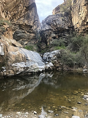


