Route Editor

| Guide | ♦ | 13 Triplogs | 0 Topics |
details | drive | no permit | forecast | 🔥 route |
stats |
photos | triplogs | topics | location |
| 193 | 13 | 0 |
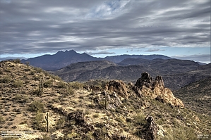
Peak 2881 - Horns Of Dilemma - Willow Creek Loop by Yoder  Overview OverviewThis hike combines three Goldfield hikes into a 7-mile loop covering a range of terrain from mountain peaks to stream beds. • Peak 2881 • Horns of Dilemma • Willow Creek to Saguaro Lake The route can be described in the following segments (in order) 1) Follow faint dirt road (0.7 miles) 2) Follow a faint trail to Peak 2881 (0.7 miles) 3) Ridgeline following Cairns to Gap (1.4 miles) 4) Traverse to Horns of Dilemma (0.7 miles) 5) Horns of Dilemma Trail to Willow Creek (0.8 miles) 6) Willow creek to car (2.7 miles)
Parking for this hike is on the east side of Highway 88 at a small dirt pull-out big enough for 2-3 cars Dirt road (0.7 miles) Cross the road and drop down into Willow Creek and follow a faint dirt road roughly following the creek bed going in the North-West direction. Eventually, the road parts way from the creek and heads more up-hill. Finally, the road disappears and is replaced with a trail. The trail continues up-slope and continues to thin-out and eventually disappears, but several cairns help lead the way. Trail and Cairns to Peak 2281 (1.4 miles) Continue up to Peak 2281, following what game trails and cairns you can find. I did re-enforce some cairns on this section and added more cairns at points of convergence of tracks. Ridgeline to Gap (2.8 miles) From Peak 2881, we are heading North-West (Mostly North) following the ridgeline until you come on a gap in the rock where you can look North East and see the Horns of dilemma. I did re-enforce some cairns on this section and added more cairns at points of convergence of tracks. Traverse to Horns of Dilemma (3.5 miles) From the gap in the rock, traverse North-East to the Horns of Dilemma, where you can pick up the Horns of Dilemma trail (Finally, a real trail). Horns of Dilemma to Willow Creek (4.3 miles) Follow the Horns of Dilemma trail to Willow Creek. There are a few variations of this trail that can be followed here to the creek. Willow Creek to Car (7.0 miles) Follow the creek for the remainder of this hike. This is a long slog (tough on the ankles) with a few sections with seasonal waterfalls and deep pools that must be traversed or gone around. Compendium Credit for this route, in no particular order, includes trekkin_gecko (2021-01-08), adilling (2021-01-16), and hikerdw (2014-11-26). All are excellent variations of the same loop. I realized much of this loop would be off-trail, so I downloaded all three GPS tracks, flagged where most of these tracks converged, and figure these convergence points would represent a trail by consensus, thus the name 2881 Consensus Loop, rather than Peak 2881 - Horns Of Dilemma - Willow Creek Loop. Check out the Official Route and Triplogs. Leave No Trace and +Add a Triplog after your hike to support this local community. | ||||||||||||||||||||||||||||||||||||||||||||||||||||||||||||||||||||||||||||||||||||||||||||||||||||||||||||||||||||||||||||||||||||||||||||||||||||||||||||||||||||||||||||||||||||||||||||