username
X
password
register
for free!
help
  

Tower Bridge - Bryce Canyon, UT

Guide 3 Triplogs  0 Topics
  4.5 of 5  
Fav
Wish
0
details
drive
permit
forecast
map
stats
photos
triplogs
topics
location
55 3 0
Statistics
tap row or icons for details
Difficulty 2 of 5
Distance One Way 1.5 miles
Trailhead Elevation 7,993 feet
Elevation Gain 600 feet
Accumulated Gain 600 feet
Avg Time One Way 2 hours
Kokopelli Seeds 3.5
unreported if dogs are allowed
editedit > ops > dogs to adjust
feature photo
Photos Viewed All MineFollowing
38  2023-07-06 tibber
17  2021-04-22 paulhubbard
Author
author avatar Guides 7
Routes 19
Photos 3,021
Trips 191 map ( 756 miles )
Age 67 Male Gender
Location Mesa, AZ
Associated Areas
list map done
Southwest Region
Historical Weather
Trailhead Forecast
Expand Map
Preferred Mar, Apr, Aug, Oct
Seasons   Spring to Late Autumn
Sun  6:01am - 6:54pm
1 Route
 
1 Alternative


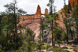
An introduction to Bryce Canyon
by paulhubbard

Overview
If you've never been IN Bryce Canyon, this is a great trail to start with! It's at one of the first 'points' just off of Sunrise Point. It's one of those trails that keeps beckoning you on further, as you just have to see what around the next bend!


The Hike
You start on the Fairyland Loop Trail, heading down into the base of Bryce Canyon (which is not really a "canyon", but more of a series of amphitheaters). Surrounded by the soft, reddish-white soil and hoodoos everywhere, this is a really enjoyable, wide, smooth, and very scenic trail. You'll keep descending until you get to the bottom of the 'canyon' where there's a wash that could have water during a rainstorm. Shortly after reaching the bottom, you'll see a sign for Tower Bridge. Follow it for 100 or so yards, and look up to your right to find the bridge and its accompanying window arch (you can't really miss it).
remove free decal offer
At this point, return the way you came. Or you could continue on the Fairyland Canyon Trail for 4 miles, but it will leave you around 1.5 miles from where you parked. If you want to do the loop (5.5 miles total), I would suggest starting at Fairyland Canyon and going clockwise to arrive at Sunrise Point - It's a downhill hike to get back to your car that way.

2021-04-30 paulhubbard
  • 2020 Bryce Canyon Visitors Guide
    area related
    2020 Bryce Canyon Visitors Guide


Check out the Triplogs.
Leave No Trace and +Add a Triplog after your hike to support this local community.

One-Way Notice
This hike is listed as One-Way.

When hiking several trails on a single "hike", log it with a generic name that describes the hike. Then link the trails traveled, check out the example.
WARNING! Hiking and outdoor related sports can be dangerous. Be responsible and prepare for the trip. Study the area you are entering and plan accordingly. Dress for the current and unexpected weather changes. Take plenty of water. Never go alone. Make an itinerary with your plan(s), route(s), destination(s) and expected return time. Give your itinerary to trusted family and/or friends.

 Permit $$
NPS

Bryce Canyon National Park
Per vehicle good for 7 days Entrance Fee Information


 Directions
or
 Road
Paved - Car Okay

To hike
From Bryce City Utah, head south into Bryce Canyon National Park. Sunrise Point is the first left turn once in the park.
page created by paulhubbard on Apr 30 2021 2:31 pm
 90+° 8am - 6pm kills
helpcorrectionissue

end of page marker