 Route Editor

| Guide | ♦ | 4 Triplogs | 0 Topics |
details | drive | permit | forecast | 🔥 route |
stats |
photos | triplogs | topics | location |
| 0 | 4 | 0 |
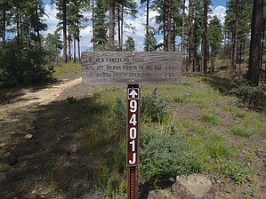
Sierra Prieta Skyway by nonot   Overview OverviewThis is an old forest road, now a named and numbered hiking/biking/equestrian trail, one of two options linking Sierra Prieta (Dark Mountain) Trail #366 to the rest of the Thumb Butte trail system. This trail is used as part of a loop hike since it neither starts nor ends at a trailhead.
From the intersection of Potts Creek #327 at the intersection with High Valley Ranch Trail #391, observe the sign and start hiking to your west. Initially, it is obvious you are on an old forest road, that in short times, gets very rocky, and in places, quite steep. As you break above the trees you will get some views of Thumb Butte to your north/northeast, and Granite Mountain north/northwest. After finishing the steep bit, the trail feeling changes from a rocky old road to that of an actual trail and becomes more pleasant, though it is still entirely uphill. As you continue to climb, you will begin to observe the large mass of Williams Peak in front of you. As you reach the top of a ridgeline, you will find a generally sandy area, where you will encounter the intersection with Sierra Prieta Trail #366 or Old Forest Road #9707T trails, allowing you to continue your loop hike. Check out the Official Route and Triplogs. Leave No Trace and +Add a Triplog after your hike to support this local community. One-Way Notice This hike is listed as One-Way. When hiking several trails on a single "hike", log it with a generic name that describes the hike. Then link the trails traveled, check out the example. | |||||||||||||||||||||||||||||||||||||||||||||||||||||||||||||||||||||||||||||||||||||||||||||||


