 Route Editor

| Guide | ♦ | 1 Triplog | 0 Topics |
details | drive | permit | forecast | 🔥 route |
stats |
photos | triplog | topics | location |
| 13 | 1 | 0 |
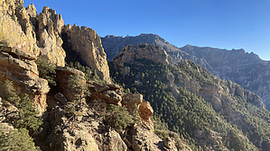
A portal to the other side by chumley   Overview OverviewA solid climb to the base of Cathedral Rock with views across the Cave Creek valley and to the Chiricahua crest. Hike The early part of the trail is well-worn and easy to follow as it climbs slowly up the slope above Cave Creek. About a quarter-mile up the trail and about 100 yards past the forest service boundary a cairn marks a worn path leading uphill to the right. This spur leads to a site with some pictographs. Make the quick trip there, or skip it and continue on the main route traversing the slope.
The trail now climbs about 300 feet before reaching a junction that is very difficult to discern. The much more visible route -- and wrong way! -- heads left and climbs up to the ridge. I didn't see signs of a route down the east side of the ridge, but apparently, you can continue here and connect down to the Hummingbird Trail near Cienega Spring just east of Portal. Rather than going left and climbing to the ridge, the correct way goes right at the junction, and from this point to the end at the base of Cathedral Rock the route is much less defined, overgrown, and more of a challenge to follow. There is some good tread if you look for it and occasional cairns provide assistance along the way. This stretch of the trail descends a bit before crossing another shoulder and then turning toward the saddle and the final climb to the base of Cathedral Rock. The trail abruptly ends with no fanfare. The view to the south reveals Portal Peak and the Chiricahua high country. The north view is somewhat obstructed by the wooded landscape. Above you, the sheer face of Cathedral Rock rises 300 feet above. It looks like it would be possible to drop down the north side of the saddle directly into Stewart Campground, though it would be a bushwhacking adventure for the ages. More realistically, you should turn around, stick to the trail, and return the way you came. Hike Distance As indicated, the stats here represent a one-way hike. Because the trail dead-ends most hikers will return the same way, for about a 6-mile hike. Exploring the pictograph site and the two viewpoint spurs may add up to another mile. Water Sources There are no reliable sources of water along this trail. Access The trailhead is located on the private property of Cave Creek Ranch. You may wish to stop at the registration desk in the main house to let them know you'll be hiking the trail. Birders are asked to pay a fee, but hikers may access the adjacent forest land and trail for free. Check out the Official Route and Triplog. Leave No Trace and +Add a Triplog after your hike to support this local community. One-Way Notice This hike is listed as One-Way. When hiking several trails on a single "hike", log it with a generic name that describes the hike. Then link the trails traveled, check out the example. | |||||||||||||||||||||||||||||||||||||||||||||||||||||||||||||||||||||||||||||||||||||||||||||||||||


