username
X
password
register
for free!
help


Tortolita Lasso Loop, AZ

Guide 7 Triplogs  0 Topics
  4 of 5  
Fav
Wish
0
details
drive
no permit
forecast
route  
stats
photos
triplogs
topics
location
58 7 0
Statistics
tap row or icons for details
Difficulty 2.5 of 5
Route Finding 1 of 5
Distance Lasso-Loop 13.25 miles
Trailhead Elevation 2,803 feet
Elevation Gain 1,430 feet
Accumulated Gain 2,075 feet
Avg Time Round Trip 6 hours
Kokopelli Seeds 23.63
 Interest Historic
 Backpack Possible - Not Popular
feature photo
Photos Viewed All MineFollowing
Inaugural Calculation on Button Tap!
4  2022-08-21 fricknaley
30  2022-01-08
Tortolita Figure-Eight
John10s
24  2021-12-22 Jim
Author
author avatar Guides 73
Routes 176
Photos 10,174
Trips 2,324 map ( 14,158 miles )
Age 46 Male Gender
Location
Associated Areas
list map done
Tucson Region
Historical Weather
Trailhead Forecast
Radar Map
Expand Map
Preferred Dec, Jan, Feb, Mar → 9 AM
Seasons   Late Autumn to Late Spring
Sun  6:02am - 6:43pm
Official Route
 
1 Alternative


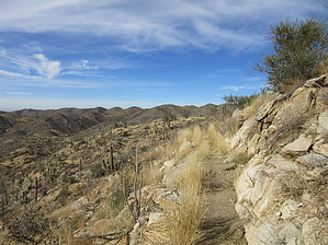
Round up the Tortolitas
by Jim

 
This hike is a relatively easy lasso loop in the heart of the Tortolitas that uses 4 different trails to access the higher areas of the range. It is described as a clockwise loop.


From the Wild Burro Trailhead, hike north up canyon on the Wild Burro Trail. As you enter the upper basin you pass by the Alamo Springs or Cottonwood Springs. The Cottonwood is dead, but the remains of the well are still in the wash.
remove free decal offer
Continue hiking on the Wild Burro to Burro Tank; a large tank and old windmill converted to a solar pump, holding water for cattle or sheep. You can't miss it. From the tank, the trail continues as the Burro Loop Trail and begins to gain elevation on very gentle switchbacks above the old dam. Expansive views of the upper basin are plentiful, as is at least 1 crested saguaro.

The trail turns into the Ridgeline Trail at the far east side of the basin. The ridgeline offers great views of the Catalina Mountains, as well as a lot of the surrounding area. There is another crested saguaro along the upper sections of the Ridgeline trail.

The Ridgeline trail gradually loses elevation as it works its way back towards the Alamo Springs Trail. The last leg is a short section of the Alamo Springs Trail and then you return to the trailhead back on the Wild Burro.

2021-12-22 Jim


    Check out the Official Route and Triplogs.
    Leave No Trace and +Add a Triplog after your hike to support this local community.
    WARNING! Hiking and outdoor related sports can be dangerous. Be responsible and prepare for the trip. Study the area you are entering and plan accordingly. Dress for the current and unexpected weather changes. Take plenty of water. Never go alone. Make an itinerary with your plan(s), route(s), destination(s) and expected return time. Give your itinerary to trusted family and/or friends.

     Permit $$
    None


     Directions
    or
     Road
    Paved - Car Okay

    To Wild Burro Trailhead
    From I-10 in north Tucson take Tangerine Road exit (#240) and head east. In about 5 miles the 1st stoplight you come to is Dove Mountain Blvd. Take left here and follow the road roughly 4 miles around the west end of the Tortolitas. Just past The Gallery is a small well-signed trailhead for Wild Burro Trail. This is on your right.

    From PHX (I-10 & AZ-51) 103 mi - about 1 hour 44 mins
    From TUC (Jct 1-10 & Grant) 21 mi - about 36 mins
    From FLG (Jct I-17 & I-40) 246 mi - about 3 hours 58 mins
    page created by Jim on Dec 22 2021 8:30 pm
     90+° 8am - 6pm kills
    helpcorrectionissue

    end of page marker