Route Editor

| Guide | ♦ | 3 Triplogs | 0 Topics |
details | drive | permit | forecast | 🔥 route |
stats |
photos | triplogs | topics | location |
| 27 | 3 | 0 |
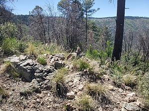
Fly Away by Mike_W   Overview OverviewThis is a short hike that starts at the *Butterfly trail* and uses that trail to access a not so well known peak called Butterfly peak. Please read the guide for Butterfly Trail #16 as you will be on that trail for just under 1 mile before reaching the junction that extends North / Northeast out to Butterfly peak. The elevation at the peak is lower than the trailhead which is not your ordinary hike. Hike Start at the well-known and wonderful Butterfly trail which begins as a nice road heading slightly downhill. The road will turn into a trail continuing down, winding across the mountainside. There are times this trail is quite narrow and you'll be squeezing through ferns and other non-thorny vegetation on both sides, but the trail will open up again. After about 0.9 miles, you'll see some logs that border the trail on a downhill section. Right in this area, I saw a beautiful kingsnake (see photos) on the trail and when I got closer, it moved off the trail and went down into a hole in the ground. The kingsnake is non-venomous, but it does look similar to a coral snake which is venomous.
Check out the Official Route and Triplogs. Leave No Trace and +Add a Triplog after your hike to support this local community. | ||||||||||||||||||||||||||||||||||||||||||||||||||||||||||||||||||||||||||||||||||||||||||||||||||||||||||