Route Editor

| Guide | ♦ | 123 Triplogs | 1 Topic |
details | drive | permit | forecast | route |
stats |
photos | triplogs | topic | location |
| 289 | 123 | 1 |
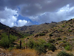
Favorite summer morning hike by bmaaske   As a west valley resident, this is one of my favorite quick summer hikes because I can be done with this hike before 9 am and it gets too hot. This hike has a sufficient amount of up and down to be a little challenging and the scenery is pretty good. Willow Spring flows year-round, although it is typically barely a trickle into a puddle. As a west valley resident, this is one of my favorite quick summer hikes because I can be done with this hike before 9 am and it gets too hot. This hike has a sufficient amount of up and down to be a little challenging and the scenery is pretty good. Willow Spring flows year-round, although it is typically barely a trickle into a puddle.This loop starts on the Mesquite trail for about 4 miles, jumps on the Ford Canyon trail for about a mile, returns on the Willow Canyon trail for about 2 miles, and then comes back on the Mesquite trail for 2 miles. The Mesquite portion of the trail is the most challenging, with a combination of large rocks and loose rocks.
Hike Start at the parking lot and head directly west to the well-marked trailhead. You will cross junctions with several trailheads in the first 1/2 mile while still on fairly flat ground. After that, you will begin a nice climb that continues for about 4 miles. After 2 miles you will reach the junction of the Mesquite & Willow Trails. You can go left for Mesquite or right for Willow. It doesn't matter since it's the same loop either way. I usually go left on Mesquite. Continuing on Mesquite for about another 2 miles until you reach the junction of the Mesquite, Goat Camp & Ford Canyon trails. Go right on Ford Canyon Trail and continue on it for about 0.9 miles until you reach the junction of Ford Canyon & Willow Canyon trail. Go right on Willow and continue for 2 miles until you reach the junction with Mesquite again where you will go left and continue 2 miles back to the trailhead. Willow Spring can be found shortly after getting on the Willow Canyon trail. You will begin descending and will notice a spot with a significant man-made rock wall/fence and a large galvanized steel watering trough. The trail heads left here but if you go right a very short distance you will reach the top of the canyon and the spring/puddle. I usually find this a good spot to take a break and have some breakfast. White Tank Park is a great place to see desert wildflowers bloom in the springtime. A couple of years ago, after a wet winter, there were flowers chest high, as far as you could see.
Check out the Official Route and Triplogs. Leave No Trace and +Add a Triplog after your hike to support this local community. | ||||||||||||||||||||||||||||||||||||||||||||||||||||||||||||||||||||||||||||||||||||||||||||||||||||||||||||||||||||||||||||||||||||||||||||||||||||||||||||||||||||||||||||||||||||||||