Route Editor

| Guide | 0 Triplogs | 0 Topics |
details | drive | permit | forecast | 🔥 route |
stats |
photos | triplogs | topics | location |
| 14 | 0 | 0 |
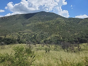
the other Apache Peak by Mike_W   Overview OverviewNot to be confused with the more popular and higher Apache Peak in the Whetstones, this is a not-so-popular peak on Oracle ridge in the Catalinas that involves an optional 4x4 road hike, a 1-mile section of Arizona Trail - Passage #12, and a 1/2 mile bushwhack that's a bit challenging, especially during monsoon season! Hike From where I parked, I walked the 4x4 road going West about 3/4 mile. From the first junction in the road make a right. At the second junction make a left. At the third junction, basically stay straight. Eventually, you will see an entrance to the Arizona Trail with a parking area. If you have a capable 4x4 / high clearance vehicle you should be able to drive to this trailhead without a problem.
Note There are normally no water sources on this trail, but when I hiked it in mid-August I was caught in a monsoon storm after my bushwhack down and about 10 minutes after I reached the Arizona Trail. I found water running right down the Arizona Trail and at times I was walking in 6 inches of water. All in all, it was refreshing, but I would have preferred a less intense rain. Warning I found some large rocks that were unstable on some of the upper parts of the bushwhack. The peak had some uneven surfaces with some rock that was not stable. When grass is tall and thick, it can be impossible to see what you're walking on. Check out the Official Route. Leave No Trace and +Add a Triplog after your hike to support this local community. | |||||||||||||||||||||||||||||||||||||||||||||||||||||||||||||||||||||||||||||||||||||||||||||||||||||||||||||