Overview
This passage begins at the Marshall Gulch Trailhead. The route follows FR 10 north into Summerhaven. From Summerhaven the route crosses Catalina Highway then turns left onto FR 38 (Control Road), and then continues due north and downhill on the Oracle Ridge Trail (#1). It turns east on the Cody Trail (#9) and then reaches the end of the passage at the American Flag Trailhead.
Southern Trailhead Marshall Gulch Trailhead
Take Catalina Highway into the Santa Catalina Mountains. Near the top of the mountain range, bear left to the community of Summerhaven. Continue 1.5 miles south to the end of the road at the Marshall Gulch Trailhead. The trailhead is on the west side of the parking area.
Northern Trailhead American Flag Trailhead - FR 38 8
From Oracle, turn south at the eastern intersection of AZ 77 and East American Avenue, drive 1.5 miles on American Avenue, and then turn right onto Mount Lemmon Road. Continue 4.0 miles to American Flag Ranch Road, and turn right (west) to reach the trailheads on both sides of the road, including parking areas near the historic American Flag Ranch. The trail on the left (east) side of the road is the start of Passage 13; Passage 12 arrives from the west (right).
When hiking several trails on a single "hike", log it with a generic name that describes the hike. Then link the trails traveled, check out the example.
WARNING! Hiking and outdoor related sports can be dangerous. Be responsible and prepare for the trip. Study the area you are entering and plan accordingly. Dress for the current and unexpected weather changes. Take plenty of water. Never go alone. Make an itinerary with your plan(s), route(s), destination(s) and expected return time. Give your itinerary to trusted family and/or friends.
Permit $$
no fees or permits reported
if incorrect tell us about it
Coronado Forest MVUMs are rarely necessary to review unless mentioned in the description or directions Coronado Motor Vehicle Use Maps (MVUMs)
Directions
Road
To hike
page created by joebartels on Jan 09 2010 12:41 am
 Route Editor


 Overview
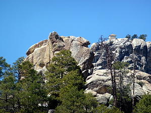


