 Route Editor

| Guide | ♦ | 3 Triplogs | 0 Topics |
details | drive | permit | forecast | route |
stats |
photos | triplogs | topics | location |
| 123 | 3 | 0 |
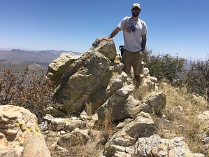
I prefer the alliteration of "Polaris Peak"... by John10s  Overview OverviewNorth Star Peak 6041, located near Hidden Pasture, is the second-highest point in the Little Rincon Mountains southeast of Tucson. The peak can be accessed via a relatively straightforward off-trail hike and offers impressive views of Rincon Peak, Forest Hill, and a variety of other surrounding peaks and ranges. If you're visiting North Star, you can extend the outing by continuing to Hidden Pasture for a round-trip hike of ~10 miles. Hike The majority of the hike follows the Hidden Pasture Route, which is itself an off-trail hike, and this one begins at the same spot, an unmarked dirt pullout along N. Mescal Road, roughly a mile north of Miller Flats Campground #2. There's no official trail, but from the parking area, start heading east and pick up a social trail that parallels a barbed wire fence and begin following that to the north. Rincon Peak is visible to the northwest, and after ~0.25 miles, the trail passes through a gate and turns to the northeast, overlooking a rugged, unnamed canyon below.
A little under three miles in, the informal trail will turn to the east/southeast, and a draw will come into view on the right side of the trail. There are multiple ways to access North Star Peak, and this draw offers one relatively straightforward approach. I chose to leave the Hidden Pasture Route to start up the draw at 32.110533, -110.430757. From this vantage point, it can be difficult to discern exactly what you're aiming for, but North Star is on the left (north) side of the draw as you look up. Once again, there's no wrong way to approach it. From the point you leave the trail to start up the draw, there's a climb of ~1,000 feet in roughly three-quarters of a mile, depending on how directly you approach North Star. In general, choose the path of least resistance as you follow the left side of the draw. It's a fairly steep ascent but not terribly overgrown, so dodging thick brush isn't a major issue. Footing is solid most of the way, with minimal scree and a lot of cryptobiotic soil that provides solid purchase underfoot. There are several rock outcroppings on the ascent that I found easier to go around rather than trying to scramble up and over. The final hurdle before reaching the summit is finding a safe route onto the ridge just north of the peak. Once you've gained the ridge, there's a USGS survey marker as you make your way southeast to the high point. From the summit, you have impressive views of the surrounding area, including Rincon Peak to the west, which is visible for most of the hike, Forest Hill to the north, and Mount Bruce and North West Dome far to the south. There's a summit register buried under some rocks at the peak, placed in 1996 by the Angeles Chapter of the Sierra Club. Once you've enjoyed the summit, you can retrace your steps back down the draw to reconnect with Hidden Pasture Route. From there, you can either hike back out the way you came in or continue to Hidden Pasture, which will extend the outing to a little under 10 miles round-trip. As previously noted, there are multiple ways to access North Star Peak, and you could descend directly into Hidden Pasture using an alternate route that follows the north-south ridge on which North Star sits. I recommend checking other trip logs and routes from Hidden Pasture if you decide to go that way. Gate Policy: If a gate is closed upon arrival, leave it closed after you go through. If it is open, leave it open. Leaving a closed gate open may put cattle in danger. Closing an open gate may cut them off from water. Please be respectful, leave gates as found. The exception is signage on the gate directing you otherwise.
Check out the Official Route and Triplogs. Leave No Trace and +Add a Triplog after your hike to support this local community. One-Way Notice This hike is listed as One-Way. When hiking several trails on a single "hike", log it with a generic name that describes the hike. Then link the trails traveled, check out the example. | ||||||||||||||||||||||||||||||||||||||||||||||||||||||||||||||||||||||||||||||||||||||||||||


