username
X
password
register
for free!
help


Wasson Peak via Sendero Esperanza Trailhead, AZ

Guide 8 Triplogs  0 Topics
  4 of 5  
Fav
Wish
0
details
drive
permit
forecast
route  
stats
photos
triplogs
topics
location
7 8 0
Statistics
tap row or icons for details
Difficulty 2.5 of 5
Route Finding 1 of 5
Distance Round Trip 7.6 miles
Trailhead Elevation 2,986 feet
Elevation Gain 1,693 feet
Accumulated Gain 1,770 feet
Avg Time Round Trip 4 hours
Kokopelli Seeds 16.45
 Interest Peak
 Backpack No
 Dogs not allowed
feature photo
Photos Viewed All MineFollowing
7  2022-09-11 Jim
Author
author avatar Guides 73
Routes 176
Photos 10,174
Trips 2,324 map ( 14,158 miles )
Age 46 Male Gender
Location
Historical Weather
Trailhead Forecast
Radar Map
Expand Map
Preferred Oct, Nov, Feb, Mar → 10 AM
Seasons   Early Autumn to Late Spring
Sun  6:02am - 6:45pm
Official Route
 
1 Alternative


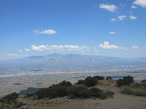
"Isolated" Wasson Hike
by Jim

 
Wasson Peak is accessible from numerous trailheads, both from within Saguaro National Park West and also from just off of the park land on Pima County land. The Sendero Esperanza Trailhead is deep within Saguaro National Park West and may be the most remote of the park's trailheads. Hiking Wasson Peak from this trailhead is slightly longer than from Kings Canyon, but substantially shorter than using the Sweetwater Trail.


After reaching the trailhead, which is one of the more difficult to reach in the park, the hike is simple enough. You'll hike the Sendero Esperanza Trail from the parking lot south to the ridge. It's an easy well maintained desert trail to the junction with the Hugh Norris Trail, which you'll take the rest of the way to the summit of Wasson Peak. Initially, the trail is fairly level, but as you near the ridge, you will ascend switchbacks. The description for the Sendero Esperanza Trail is written from the south and the Kings Canyon Trail, but trailhead access for the trail is off of the Golden Gate Rd.
remove free decal offer
The Hugh Norris Trail is one of the best trails I have ever walked on, anywhere. I once hiked downhill from Amole Peak to the junction with the Sendero Esperanza Trail barefoot. Views on the ridgeline are plentiful, and it is a pretty enjoyable hike to Wasson. Once on Wasson, enjoy the view and return the way you came.

2022-09-10 Jim
  • Rincon HAZ Map
    area related
    Rincon HAZ Map
  • Rincon Mountain Distric East
    area related
    Rincon Mountain Distric East
  • Tucson Mountain District West
    area related
    Tucson Mountain District West
  • SNP Cactus Forest Map
    area related
    SNP Cactus Forest Map
  • nps related
  • sub-region related


Check out the Official Route and Triplogs.
Leave No Trace and +Add a Triplog after your hike to support this local community.
WARNING! Hiking and outdoor related sports can be dangerous. Be responsible and prepare for the trip. Study the area you are entering and plan accordingly. Dress for the current and unexpected weather changes. Take plenty of water. Never go alone. Make an itinerary with your plan(s), route(s), destination(s) and expected return time. Give your itinerary to trusted family and/or friends.

 Permit $$
NPS

Saguaro National Park
2022 $25 vehicle • $20 motorcycle • $15 individual on foot or bicycle
Receipt is valid for 7 days
$45 Annual Park Pass View All

No fee required from Miller Creek Trailhead off Mescal Rd.


 Directions
or
 Road
FR / Dirt Road / Gravel - Car Okay

To hike
The Sendero Esperanza Trailhead is within Saguaro National Park West. Access is from Golden Gate Rd off of Sandario Rd, 3.7 miles south of the intersection with Picture Rocks Rd. Formerly, Golden Gate Rd was open from Picture Rocks Rd, but this no longer appears to be the case with it having been converted to a multi-use trail after 2020, beyond the trailhead.

Exit #248, Ina Rd, on I-10 and proceed west to Wade Rd. Turn left onto Wade Rd and head south. Wade becomes Picture Rocks Rd as it turns towards the Tucson Mountains and crosses over them. Follow Picture Rocks Rd to Sandario Rd, and turn left or south. Follow Sandario to Golden Gate Rd, turn left or east, and enter the park here, continue on Golden Gate Rd to the trailhead, which is on your right after 3.6 miles. Golden Gate Rd is graded gravel.

page created by Jim on Sep 10 2022 2:24 pm
 90+° 8am - 6pm kills
helpcorrectionissue

end of page marker