Hike: From the Lake Darling trailhead, head north on Lake Darling Trail 52 for approx 0.30 miles to the start of Gordon Creek Trail 161. There is a brown sign on a tree on the right side of the junction. At this sign, turn left and head west on Gordon Creek Trail.
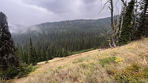
Despite the name, you will never actually see Gordon Creek while on this trail, although you did cross over the creek on the wood bridge just before the junction. You can hear the creek in a few places before the trail climbs too high. There is one switchback early on, then the trail heads northwest as you steadily climb uphill. Views to the south are nice, but the dense forest mostly limits how far you can see. The trail is narrow, with some vegetation to push through, but overall in good condition. The upper third of the trail is slightly steeper, which you will notice as you approach the terminus of the trail where it meets the Pend Oreille Divide Trail #67.
Warning: Black bears, grizzly bears, and moose all reside in the area. Be alert and carry protection of your choosing. There is no cell service along this trail.
When hiking several trails on a single "hike", log it with a generic name that describes the hike. Then link the trails traveled, check out the example.
WARNING! Hiking and outdoor related sports can be dangerous. Be responsible and prepare for the trip. Study the area you are entering and plan accordingly. Dress for the current and unexpected weather changes. Take plenty of water. Never go alone. Make an itinerary with your plan(s), route(s), destination(s) and expected return time. Give your itinerary to trusted family and/or friends.
Permit $$
FS
Directions
Road
FR / Jeep Road - Car possible when dry
To hike From Coeur d'Alene, take US-95 north to Sandpoint. At Sandpoint, take Hwy 200 East to Trestle Creek Rd. Turn left on Trestle Creek Rd, which turns into FS-275. Take FS-275 up to where it ends at FS-419. Turn left at FS-419 and take it another mile to where the road sign indicates Trail 52 & 161 ahead of you on the left. If you are in a car, park along FS-419 near this sign; if you have medium clearance or better, you can drive the couple hundred feet up to the dirt parking area at the trailhead. There are two or three road signs along the drive, so finding the trailhead is easy.
FS-275 is car-friendly. FS-419 is rougher, but almost any car could make it when it is dry. Medium clearance would be better.
 Route Editor


