 Route Editor

| Guide | ♦ | 1 Triplog | 0 Topics |
details | drive | permit | forecast | route |
stats |
photos | triplog | topics | location |
| 21 | 1 | 0 |
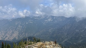
impressive rise over run by LindaAnn Hike: The start of Goat Mountain #135 is marked with brown signs on the east side of Lightning Creek Road. There is no warmup on this hike, the uphill begins immediately. The trail immediately enters the forest and steeply switchbacks up the west side of Goat Mountain. As you climb, you can see the Lightning Creek drainage both behind you to the west, and off to your left looking north. Climb a little higher, and Lake Pend Oreille comes into your view to the west.
At about 2.50 miles, congratulate yourself because you have just ascended 3200' and the trail starts to become much less steep. To make up for that, the deadfall increases, and the trail is vague in many places. A half mile later, the summit of Goat Mountain comes into view, along with some great views to the north and east, and the trail drops about 100' before the final climb up to the summit. There's less deadfall in this final half-mile climb, but the trail is almost nonexistent these days, which doesn't matter, just head up through the path of least resistance. Nearing the summit, the terrain switches to mostly talus, but staying slightly to the north edge of the ridge avoids most of it. At the summit, there are places to sit on the low rocks and enjoy the views. Scotchman Peak is easily visible nearby to the southeast, and from there, an impressive ridge of mountains is visible to the east, including Blacktop Mountain and Scotchman No 2. Enjoy your break at the summit, because it's a strenuous hike back downhill. Warning: Be aware of potential encounters with typical northern Idaho wildlife, including black bears, grizzlies, moose, and mountain goats. There is no water along the Goat Mountain Trail, which probably helps reduce the likelihood of an encounter, but prepare accordingly. Check out the Official Route and Triplog. Note This is a difficult hike. Arrive fit and prepared or this could get ugly. Leave No Trace and +Add a Triplog after your hike to support this local community. One-Way Notice This hike is listed as One-Way. When hiking several trails on a single "hike", log it with a generic name that describes the hike. Then link the trails traveled, check out the example. | |||||||||||||||||||||||||||||||||||||||||||||||||||||||||||||||||||||||||||||||||||||||||


