Route Editor

| Guide | ♦ | 1 Triplog | 0 Topics |
details | drive | permit | forecast | 🔥 route |
stats |
photos | triplog | topics | location |
| 44 | 1 | 0 |
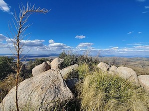
cause it was there! by Mike_W   Overview OverviewPeak 5961 is about 3/4 of a mile north of the Charouleau gap which is a saddle on Samaniego ridge at about 5,080 feet. Even though the Charouleau gap road is an old 4x4 road, it is currently very washed out, very steep in some places, and would be impossible to drive without a very capable dune buggy or quad with the right kind of tires and an experienced driver. There are many parts of this road I would not even attempt with my 4x4 high clearance Chevy truck. If you don't have the right kind of vehicle you'll probably need to walk the entire length of it.
Start off taking the Charouleau gap 4x4 road to the northeast. The road will wind a bit but in general, you will be heading to the east. In fact, you can see the gap from a distance at the staging area looking to the east. It's the low point on Samaniego ridge where it is easiest to cross through. In the first 2 miles of the road, you will cross 2 washes. These washes are sandy in the middle and quite rocky and the way down and up. After traveling for over 2 miles, I ran into a confusing area where the road seemed to disappear and it was all rock. Just keep going forward and you will see the road continue. After 2 miles, there are a few splits and it doesn't matter which direction you take because they all seem to join back together. At 3.25 miles, you'll see a split. If you take the right split, the road appears to dead-end at a rocky wall. If you are walking, it's fairly easy to climb over and walk past that wall. If you are driving take the left route at 3.25 miles. Either way, the road is very steep here and I wouldn't attempt it even with my 4x4 high-clearance truck. After roughly 6.5 miles total, you should have made it to the gap. There's a cattle guard here with a trail junction and a trail heading up Samaniego ridge to near the top of Mt Lemmon. Looking to the east you can see Oracle ridge. If you look to the north you will see the false summit of peak 5961. From this point, I hiked up the grassy slope. Eventually, I got to a barbed wire fence line which made sense to cross under to reach the high point easier. It got progressively steeper and rockier as I got closer to the top. I found it to be easier to stay to the left of the high point. Once I got higher up, I was able to reach the high point on the top of the ridge. Once on the top of the ridge, it was relatively easy to walk north to the high point of Peak 5961 which was about 1/2 mile north of the false summit. There was some up and down on this ridge, but it was pleasant and much easier than the steep bushwhack. At the high point (Peak 5961), I found a registry between a few large rocks. On the registry, I counted 11 names (among 6 parties) in almost an 11-year period from early 2012 to today, so that's roughly 1 visitor per year on average. There were some nice views from up here but the "reward per mile" was on the low side since this was a very long hike. If you like remote peaks that almost nobody hikes to then this may be a peak for you. Check out the Official Route and Triplog. Leave No Trace and +Add a Triplog after your hike to support this local community. | |||||||||||||||||||||||||||||||||||||||||||||||||||||||||||||||||||||||||||||||||||||||||||||||||||||||||||