Route Editor

| Guide | ♦ | 1 Triplog | 0 Topics |
details | drive | permit | forecast | 🔥 route |
stats |
photos | triplog | topics | location |
| 26 | 1 | 0 |
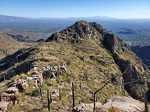
Crisp Perch by Mike_W  Overview OverviewMount Miguel is roughly a 3.6-mile hike up the very well-maintained Esperero Trail #25 in Sabino Canyon, followed by a 0.75 mile moderate bushwhack to the peak. After reaching the peak, I found it easier to bushwhack down roughly 0.4 miles to the east, and then eventually ran into a lower part of the Esperero Trail which I took to get back down. Hike Start at Sabino Canyon, either the main parking area or the overflow lot. I started this hike from the overflow lot and took the trails from there to the main road. Once at the main road, it's only a short distance to get to the Esperero Trail, in which you'll be turning left. There will be some hills to climb within the first mile of the Esperero Trail but the trail is very easy to follow. You'll pass through a gate within the first mile.
To get down, the easiest and shortest way from the peak would be to bushwhack to the east, following the slope down to the Esperero Trail using the most gentle route. This route down could also be used to get up to the peak faster and it would appear to save about 1 mile from the one-way route. From the peak, bushwhacking back north to Cardiac Gap is also an option but it's a longer more tedious bushwhack. Once at the Esperero Trail, follow that back down roughly 3 miles to your starting point. Gate Policy: If a gate is closed upon arrival, leave it closed after you go through. If it is open, leave it open. Leaving a closed gate open may put cattle in danger. Closing an open gate may cut them off from water. Please be respectful, leave gates as found. The exception is signage on the gate directing you otherwise. Check out the Official Route and Triplog. Leave No Trace and +Add a Triplog after your hike to support this local community. | ||||||||||||||||||||||||||||||||||||||||||||||||||||||||||||||||||||||||||||||||||||||||||||||||||||||||||||