Route Editor

| Guide | ♦ | 6 Triplogs | 0 Topics |
details | drive | no permit | forecast | route |
stats |
photos | triplogs | topics | location |
| 25 | 6 | 0 |
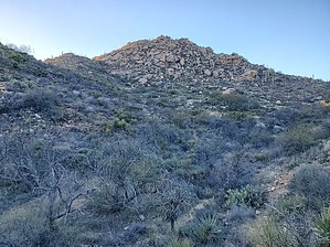
Didn't see any mustangs today, unless you count the Ford Mustang! by Mike_W  Overview OverviewPeak 4416 is the highest point on the ridge that is northwest of the Wild Mustang Trail in the Tortolita mountains. To get to this peak you will take the popular Ritz Carlton resort trails, the Upper Javelina trail, the Wild Mustang Trail, and a good unmarked trail that goes all the way to the summit. Hike Start by parking in the main parking lot for the Wild Burro trailhead. Exit the parking lot on the northwest side and walk north/northeast on N. Secret Springs Dr. for less than 1/4 miles. You will see a set of flags on the left side of the road. Continue and look for a paved path leading north from the road. Take this path and within about 50 feet you will see a trail leading west. Take this trail west for roughly 600 feet and then the trail will turn heading north. It will climb and after hiking a total of 0.75 miles from where you parked you will reach the junction of the Upper Javelina trail. Turn left here and continue for another 0.25 miles until you reach the junction of the Wild Mustang Trail. Stay to the right at this junction and continue on the Wild Mustang trail.
Next, continue along the Wild Mustang Trail. You will cross a few canyons and the trail will steadily climb for a few miles. You will want to take this trail until you have hiked a total of 3.5 miles from where you parked. From this point, start looking to your left for a trail leading up that branches off the Wild Mustang Trail. According to my GPS, the trail junction was at 3.65 miles, but your device may show a slight variation. After you're on the trail leading up for about 5 minutes, you should be able to look to the northwest and see a rocky peak that is only about 1/4 mile away. This is your final destination. Continue along the trail and look for cairns. There will be a few tricky areas closer to the summit where the trail seems to disappear. Look for cairns and if you don't see any, just continue in a straight line going up. You will eventually reach the top. There will be a few rocks to climb over but nothing too difficult and definitely nothing dangerous. At the very top, you'll see an ammo box with a registry inside. From the peak, looking north or west you will see Cochie canyon and a road leading down it. Looking southeast across Wild Burro canyon you will see Ridge Crest peak, also known as peak 4373, which is another ridge high point. Return down the same way you came and be careful to go the correct way at each junction on the way back. Check out the Official Route and Triplogs. Leave No Trace and +Add a Triplog after your hike to support this local community. | |||||||||||||||||||||||||||||||||||||||||||||||||||||||||||||||||||||||||||||||||||||||||||||||