Piety Hill - Catalinas, AZ | HikeArizona
 
  🔥

Piety Hill - Catalinas, AZ

Guide 1 Triplog Mine 0 0 Topics
 
3 of 5 
Fav
Wish
0
details
drive
no permit
forecast
🔥
route  
stats
photos
triplog
topics
location
18 1 0
Statistics
tap icons for details
Difficulty 2.5 of 5
Route Finding 2 of 5
Distance Round Trip 1.5 miles
Trailhead Elevation 4,079 feet
Elevation Gain 633 feet
Accumulated Gain 644 feet
Avg Time Round Trip 1 hour
Kokopelli Seeds 4.72
 Interest Off-Trail Hiking & Peak
 Backpack Possible - Not Popular
unreported if dogs are allowed
editedit > ops > dogs to adjust
feature photo
Photos Viewed All MineFollowing
Inaugural Calculation on Button Tap!
18  2023-01-30 Mike_W
Author
author avatar Guides 48
Routes 68
Photos 2,704
Trips 218 map ( 1,224 miles )
Age 51 Male Gender
Location Tucson, AZ
Historical Weather
Trailhead Forecast
Radar Map
Expand Map
Preferred Nov, Dec, Jan, Feb → 9 AM
Seasons   Autumn to Spring
Sun  6:20am - 6:37pm
Official Route
 
0 Alternative
 
 Water
Historic Fire Perimetersacres
🔥 2020 Bighorn Fire119.5k
🔥 2017 Burro Fire27.2k
🔥 View (All) - over Official Route 🔥
Nearby Area Water
[ View More! ]
no photo labels yet
+Add > Photos to this Guide
then label as applicable
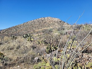
I didn't see anything sacred at the top
by Mike_W

 
Overview
Piety Hill is a remote hill that is accessible from Redington road, roughly 15 miles from the end of the paved road in northeast Tucson. There is no trail, but the brush is relatively open, so I'd classify this as an open country hike, rather than a bushwhack. There's a solar-powered antenna at the top of the mountain and a relatively flat summit.Hike
Start by heading northwest to the highest point you can see. You'll need to walk around some ocotillo and some prickly pear at the lower elevation. Cattle sometimes roam this area and can probably make it all the way up to the top, which makes for an easier hike for us. When in doubt, just follow the cattle trails up.

After hiking roughly 1,000 feet, you'll need to hike further north to cross over to the main ridge leading to the top. There will be sections that get a bit rocky. Just hike around those sections and you'll eventually see ways to go around the rock. Stay on the middle of the ridgeline and you should eventually make it to the top. If you're lucky, you may see a few pincushion cacti along the way. These are the low-flat ones that you can almost step on by accident.

Once you reach the top, you'll notice a solar-powered antenna. There's also a rock pile to the west with a registry, which is new as of January 2023. You'll see a survey marker that was placed in 1937. From the top, you'll have some nice views of Mica Mountain to the south which may be snow-capped in the Winter. To the northeast, you'll see the Galiuro Mountains, and looking west/northwest are the Catalinas.


Check out the Official Route and Triplog.

Leave No Trace and +Add a Triplog after your hike to support this local community.

2023-01-31 Mike_W
  • sub-region related
WARNING! Hiking and outdoor related sports can be dangerous. Be responsible and prepare for the trip. Study the area you are entering and plan accordingly. Dress for the current and unexpected weather changes. Take plenty of water. Never go alone. Make an itinerary with your plan(s), route(s), destination(s) and expected return time. Give your itinerary to trusted family and/or friends.

 Permit $$
None


 Directions
or
or
 Road
High Clearance possible when dry

To hike
From Tucson take Tanque Verde road until it runs into Redington road. Continue up the mountain until you reach the lower Tanque Verde falls trailhead parking lot. At this point, you'll be on a dirt road that can get bumpy at times with a fair amount of potholes up ahead. Reset your odometer here.

Continue on Redington road for 10.9 miles. At this point, there's a split in the road although both roads appear to be called Redington road. Turn left and continue in a Northern direction for roughly 3 miles. If you look to the Northwest you will see Piety Hill above you, about 600 feet up. You'll see a pullout on the left side of the road before the road turns East. This is a great place to turn around and park.
page created by Mike_W on Jan 31 2023 10:52 pm
helpcorrectionissue

end of page marker