Route Editor

| Guide | ♦ | 29 Triplogs | 0 Topics |
details | drive | no permit | forecast | route |
stats |
photos | triplogs | topics | location |
| 128 | 29 | 0 |
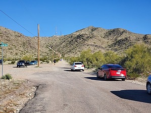
 Overview OverviewThe Casa Grande mountains high point is a relatively easy peak that is a great Winter hike. Since the peak is at only 2,350 feet, it would not be a good place to hike in Summer or when the temperature is above 90 degrees. This hike involves a gravel road, a paved road, and well-maintained trails. There is no bushwhack involved to get to the high point. From the top, you'll have nice views of the entire Casa Grande area including a view of the busy Highways I-10 and I-8 to the east and north, Picacho peak and Newman peak to the southeast, and Table Top mountain to the west. Hike Start by hiking east down Hanna road toward the radio towers. The road is paved west of the parking area and then becomes gravel. There will be a gradual incline on the gravel road and after walking about 0.6 miles there is a gate and the road becomes paved again. There's a path where hikers can get around the gate. Here's where the road gets a little bit steeper. Continue until you have hiked a total of 1.25 miles from the parking area and you will have reached the radio towers.
This summit is only 18 feet lower in elevation than the high point which is still about 0.7 miles more of the trail going up and down. To continue to the high point, hike back down to the main branch just below the Casa Grande 2 peak. Then continue for roughly 0.7 miles along the ridgeline. You will see a large American Flag here at the summit. There's also a tin container with a registry inside. In Feb 2023, this tin container was pretty banged up so please make sure you leave a rock on top of it to minimize the chance of rainwater damaging the registry entries. Continue back the same way you came to get to your starting point. 2011-08-20 written as Ridgeline Trail by PaleoRob This trail can be considered to start at the radio tower summit. This is the end of the Hanna Road and the destination of the popular Radio Tower Summit hike. Continuing past the radio towers, the trail narrows and rises as it follows the ridgeline. Just below the base of Casa Grande 2, the Bolt Trail comes in from the right (west). Either the Bolt Trail or hiking up Hanna Road will get you onto the northernmost portion of the Ridgeline Trail. Just past the Bolt Trail, the trail splits. You can go right and ascend Casa Grande 2, the second-highest point in the Casa Grand Mountains, or continue heading south. Many people summit Casa Grande 2 before continuing along the trail, and others do not. Your choice. The ridgeline is easy to follow and relatively level. There are two larger saddles between Casa Grande 2 and the flagpole that provide open views to the east and the west, while the higher points often have a few low palo verde trees clinging to them. There are several decent sized cholla fields along the route, so use care. Near Peak 2350, locally known as The Flagpole, there is a rectangular pit in the ground. This is an old copper mine, and copper traces can still be seen on the walls and in the spoils pile. Just above is the summit, where most hikers generally turn back. There is a flag on the flagpole usually - the one up there currently was flown over Afghanistan in 2010, according to the literature in the summit register. The ridgeline continues, but the established trail does not. While possible to complete an end-to-end ridgeline hike of the Casa Grande Mountains, the city has only built/maintained the trail between the radio towers and the flagpole. If you continue, tread lightly. Occasionally, especially on weekends, you may hear gunshots. This is because the City of Casa Grande operates a gun range on the mountain's SW flank. Do not be alarmed. They shouldn't be shooting at you. Gate Policy: If a gate is closed upon arrival, leave it closed after you go through. If it is open, leave it open. Leaving a closed gate open may put cattle in danger. Closing an open gate may cut them off from water. Please be respectful, leave gates as found. The exception is signage on the gate directing you otherwise. Check out the Official Route and Triplogs. Leave No Trace and +Add a Triplog after your hike to support this local community. | ||||||||||||||||||||||||||||||||||||||||||||||||||||||||||||||||||||||||||||||||||||||||||||||||||||||||||||||||||||||||||||||||||||||||||||||||||||||||||||||||||||||||||||||||||||||||||