username
X
password
register
for free!
help
  

American Peak - Patagonias, AZ

Guide 1 Triplog  0 Topics
  4 of 5 
Fav
Wish
0
details
drive
permit
forecast
route  
stats
photos
triplog
topics
location
40 1 0
Statistics
tap icons for details
Difficulty 2.5 of 5
Route Finding 2 of 5
Distance Round Trip 4 miles
Trailhead Elevation 5,156 feet
Elevation Gain 1,009 feet
Accumulated Gain 1,291 feet
Avg Time Round Trip 2-3 hours
Kokopelli Seeds 10.46
 Interest Off-Trail Hiking & Peak
unreported if dogs are allowed
editedit > ops > dogs to adjust
feature photo
Photos Viewed All MineFollowing
40  2023-05-01 Mike_W
Author
author avatar Guides 61
Routes 96
Photos 3,964
Trips 251 map ( 1,419 miles )
Age 51 Male Gender
Location Tucson, AZ
Historical Weather
Trailhead Forecast
Radar Map
Expand Map
Preferred Oct, Nov, Mar, Apr → 7 AM
Sun  5:18am - 7:27pm
Official Route
 
0 Alternative
 
 Water


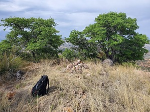
higher than beautiful
by Mike_W

Overview
American Peak is an open country hike that is southwest of Harshaw, AZ, in the Patagonia mountain area. A good route to this peak is to first hike to Hermosa Hill, which is to the north, and then hike to the saddle just north of the peak and hike up the north ridge of American Peak.


Hike
Start walking back down the road you came in on and look for a gully that parallels the main road. Follow this gully north using the instructions for Hermosa Hill. After reaching the top of Hermosa Hill, American Peak will be the higher peak that is visible to the south. It's basically an open country hike to this high point with not a lot of brush. Most of the brush is oak or pine and it's pretty easy to find paths that weave through the trees and brush. Keep heading up the north ridge and you will eventually reach the peak. There are a few oaks and pines at the summit. You'll also see a registry in a rock pile.

Once at the peak, there are 2 ways to get back down. One is to return the way you came. The second route involves hiking further to the south and looping back around to the road. This route is more difficult mainly because of the brush but you may be able to find a better route. I ended up hiking down a ridge line that was quite steep in some areas. The route down was definitely harder than the route up. If you'd prefer an easier hike, I'd suggest going back down the way you came up.

Check out the Official Route and Triplog.

Leave No Trace and +Add a Triplog after your hike to support this local community.

2023-05-05 Mike_W
    WARNING! Hiking and outdoor related sports can be dangerous. Be responsible and prepare for the trip. Study the area you are entering and plan accordingly. Dress for the current and unexpected weather changes. Take plenty of water. Never go alone. Make an itinerary with your plan(s), route(s), destination(s) and expected return time. Give your itinerary to trusted family and/or friends.

     Permit $$
    None

    Coronado Forest
    MVUMs are rarely necessary to review unless mentioned in the description or directions
    Coronado Motor Vehicle Use Maps (MVUMs)


     Directions
    or
    or
     Road
    Paved - Car Okay

    To hike
    From Tucson, take I-10 to Hwy 83 South. Take Highway 83 south to Sonoita. Turn right on Highway 82 and follow it west to the town of Patagonia. Once entering Patagonia, turn left on Taylor Ave. Take the next left on McKeown Ave. This road turns into Harshaw Ave. Continue for 9.7 miles, staying on Harshaw Ave. Take your next left on a dirt road and park on the right near a windmill.
    page created by Mike_W on May 04 2023 10:25 pm
     90+° 8am - 6pm kills
    helpcorrectionissue

    end of page marker