username
X
password
register
for free!
help
 This is likely a great time to hike this trail!  Check out "Preferred" months below, keep in mind this is an estimate. 
   🔥

Marble Peak - Catalinas, AZ

Guide 1 Triplog  0 Topics
  3 of 5  
Fav
Wish
0
details
drive
permit
forecast
🔥
route  
stats
photos
triplog
topics
location
23 1 0
Statistics
tap row or icons for details
Difficulty 2 of 5
Route Finding 2 of 5
Distance Round Trip 5 miles
Trailhead Elevation 7,782 feet
Elevation Gain -372 feet
Accumulated Gain 926 feet
Avg Time Round Trip 2.5
Kokopelli Seeds 9.63
 Interest Off-Trail Hiking & Peak
 Backpack Possible - Not Popular
unreported if dogs are allowed
editedit > ops > dogs to adjust
feature photo
Photos Viewed All MineFollowing
Inaugural Calculation on Button Tap!
23  2022-06-08 Mike_W
Author
author avatar Guides 104
Routes 256
Photos 16,118
Trips 528 map ( 2,863 miles )
Age 53 Male Gender
Location Tucson, AZ
Historical Weather
Trailhead Forecast
Radar Map
Expand Map
Preferred Apr, May, Sep, Oct → 9 AM
Seasons   Spring to Autumn
Sun  6:00am - 6:44pm
Official Route
 
0 Alternative
 
Historic Fire Perimetersacres
🔥 2020 Bighorn Fire119.5k
🔥 2003 Aspen Fire87.7 mi*
🔥 2002 Bullock46.8 mi*
🔥 View (All) - over Official Route 🔥
*perimeter length in miles


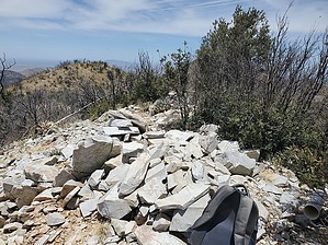
turning stones into milestones
by Mike_W

 Likely In-Season! 
Overview
Marble Peak is one of the high points on Oracle ridge. The easiest way to hike this is to start at the Oracle Ridge trailhead which is at roughly 7,800 feet elevation. Then, you will take the Oracle Ridge trail down and then up to Marble Peak. The top of Marble Peak is lower in elevation than the trailhead. The hike is mostly trail with a relatively short bushwhack to get to the peak.


Hike
Start at the Oracle Ridge trailhead hiking North. The trail goes around the West side of Mt. Hitchcock, the peak you can see from the firehouse. The trail is in pretty good shape overall and will follow the ridgeline. After hiking about 1.8 miles, you should come to a road junction. Take a right and continue for about 0.3 more miles. Next, take a sharp right and continue for about 200 feet. At this point, if you look due East this is the ridgeline that you will want to follow to the summit.
remove free decal offer
From here you only have about 120 vertical feet and about 500 feet in distance to the summit. There's no trail but you can basically follow the ridgeline to the top. There are a few places where you may need to hike 20 or 30 feet away from the ridgeline to avoid brush. There are also a few areas with loose rock so you'll want to be sure to have sound footing.

2023-05-29 Mike_W


    Check out the Official Route and Triplog.
    Leave No Trace and +Add a Triplog after your hike to support this local community.
    WARNING! Hiking and outdoor related sports can be dangerous. Be responsible and prepare for the trip. Study the area you are entering and plan accordingly. Dress for the current and unexpected weather changes. Take plenty of water. Never go alone. Make an itinerary with your plan(s), route(s), destination(s) and expected return time. Give your itinerary to trusted family and/or friends.

     Permit $$
    None

    Coronado Forest
    MVUMs are rarely necessary to review unless mentioned in the description or directions
    Coronado Motor Vehicle Use Maps (MVUMs)


     Directions
    or
     Road
    Paved - Car Okay

    To hike
    From the East side of Tucson take Catalina Highway to Mt Lemmon Highway and continue toward the town of Summerhaven. When you are near the top, getting close to Summerhaven, you will pass 3 picnic areas. Box Elder, then Alder, then Loma Linda. About 0.5 miles past the Loma Linda picnic area you will turn right on Mt Lemmon control road, pass the fire station and continue for about 1,000 feet until you see the Oracle Ridge trailhead on your left. Park here and this is where you should start your hike.
    page created by Mike_W on May 29 2023 9:46 pm
     90+° 8am - 6pm kills
    helpcorrectionissue

    end of page marker