username
X
password
register
for free!
help
  This is likely a great time to hike this trail!  Check out "Preferred" months below, keep in mind this is an estimate.
   🔥

Walla Valley, AZ

Guide 2 Triplogs  0 Topics
  2 of 5  
Fav
Wish
0
details
drive
permit
forecast
🔥
route  
stats
photos
triplogs
topics
location
5 2 0
Statistics
tap row or icons for details
Difficulty 1.5 of 5
Route Finding 1 of 5
Distance Round Trip 6.45 miles
Trailhead Elevation 7,837 feet
Elevation Gain 339 feet
Accumulated Gain 509 feet
Avg Time Round Trip 3.5
Kokopelli Seeds 9
 Interest Off-Trail Hiking & Historic
 Backpack Possible - Not Popular
 Dogs not allowed
feature photo
Photos Viewed All MineFollowing
5  2023-07-05 pseudalpine
Author
author avatar Guides 59
Routes 1,100
Photos 1,176
Trips 1,290 map ( 9,859 miles )
Age Male Gender
Location Arizona
Historical Weather
Trailhead Forecast
Radar Map
Expand Map
Preferred Sep, May, Jun, Aug → 6 AM
Seasons   Summer to Autumn
Sun  6:03am - 6:53pm
Official Route & 1 Rt
 
0 Alternative
 
Historic Fire Perimetersacres
🔥 2011 Point Fire23.9 mi*
🔥 2001 TOWER FIRE Fire20.5 mi*
🔥 1987 Sublime Fire5.4 mi*
🔥 View (All) - over Official Route 🔥
*perimeter length in miles


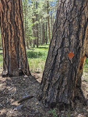
Shinrin-yoku Steeplechase
by pseudalpine

  Likely In-Season!
Overview
Google Maps classifies this valley as a ravine, but it really doesn't have steep sides and isn't deep and narrow. On many topographic maps, there is an approximately two-mile road marked. Ninety-nine percent of this old road doesn't exist anymore, but many orange/red blazes are still affixed to trees along the route. I'm not sure if this was once a historic tourist area, the boundary of the park, or if it was just a fire road. I could not find much information about the Walla Valley Peninsula, except that there was a wildfire here in June 2014. I found no evidence that the valley burned intensely, in fact, it seems to have been beneficial to this forest area.


Hike
The best way to describe this hike is Shinrin-yoku Steeplechase, sans water jumps. There aren't wide-open views of distant vistas and stunning panoramas, but there is a lot of deadfall interspersed with thick fern beds, Quaking Aspen, plentiful wildflowers, spiny Locust and Grand Canyon Rose. There are also easier sections of grassy meadows with several beefalo wallows.
remove free decal offer
The most striking aspect of this landscape is the very large ponderosa pines. The trees here don't quite rival some of the massive ponderosa pine growing along the Widforss Trail, but they are still very impressive. This hike goes about one mile past where the blazes end. There is a natural turn in the valley with an obvious small, northwest-projecting hill. This just seems like a good place to turn around, but one could hike the length of the valley, eventually transecting the Point Sublime Trail before its final extension out to the point.

Synopsis
When the inner canyon is dangerously blazing hot, this hike is an acceptable, much cooler alternative form of preventative care. I've completed it twice (autumn and summer), both times after more difficult inner canyon hikes and/or climbs and before exiting the park (AKA Reentry). It's a long, rough, taxing wheeler to Point Sublime, so why not make the most of it...

2023-07-09 pseudalpine
  • Grand Canyon Use Area Boundaries - Dynamic Map


Check out the Official Route and Triplogs.
Leave No Trace and +Add a Triplog after your hike to support this local community.
WARNING! Hiking and outdoor related sports can be dangerous. Be responsible and prepare for the trip. Study the area you are entering and plan accordingly. Dress for the current and unexpected weather changes. Take plenty of water. Never go alone. Make an itinerary with your plan(s), route(s), destination(s) and expected return time. Give your itinerary to trusted family and/or friends.

 Permit $$
NPS

Grand Canyon National Park
Details for each are occasionaly below numerous alerts
Entrance Fee
Overnight/Backpacking Permits
Grand Canyon Use Areas Map
Rim-to-Rim and Extended Day Hike/Run


 Directions
or
 Road
High Clearance possible when dry

To hike
Point Sublime Trail, just southwest of the Kanabownits Canyon junction.
page created by pseudalpine on Jul 09 2023 1:34 pm
 90+° 8am - 6pm kills
helpcorrectionissue

end of page marker