 Route Editor

| Guide | ♦ | 63 Triplogs | 2 Topics |
details | drive | permit | forecast | 🔥 route |
stats |
photos | triplogs | topics | location |
| 445 | 63 | 2 |
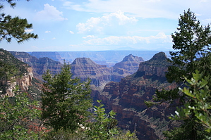
Transept View by Dschur  Overview OverviewThis trail follows along the rim of the Grand Canyon for 2.5 miles before it goes into the forest to emerge with a View of Widforss Point. Not as busy as some in the canyon but with nice views. Warning There is no water along the trail and no restrooms. And since it is at 8000 feet there can be altitude problems if not properly acclimated. And though it does go thru the forest there are quite a few trees that are burned in a fire so can be hot in the middle of summer as well as hazardous during the monsoon.
The Widforss trail is named for Gunnar Widforss who lived and painted at the Grand Canyon in the 1930s and produced a large collection of watercolors prized for their geologic detail. In his paintings, Widforss captured the Grand Canyon environment as he saw it then. Hike The Widforss trail starts at the parking lot down a dirt road not far from the North Kaibab Trailhead. There is an outhouse at the trailhead and a small parking lot. There are also trail guides for sale at the TH that describes 14 different points in the first 2.5 miles along the trail. You climb up a little from the parking lot with lots of Aspens, firs, pines, and spruces. This area is very good for pictures in the fall of the yellow leaves of the Quaking Aspen trees. The trail climbs and goes across fingers out to the canyon so it is generally flat to up and down to get out on each of the plateaus. The first sign is of a view of the meadow below it is where Gunnar Widforss had his camp during his artist days. There is also a cave over on the other side of the meadow that Uncle Jim used for hanging out during his days on the rim as Game Warden (hunter) on the north rim. The second sign is of the fossils on the trail. This trail goes all along the rim throughout the Kaibab Limestone and has lots of ocean fossils in it. Shells, crinoids, sponges, and other sea life are preserved in the limestone and cherts all along the trail. Number 3 tells of the Bright Angel spring in the canyon that used to supply all the water for the North rim but now is supplied from Roaring springs as the Bright Angel didn't support all the people in later years. Number 4 talks about the diverse forests from the north side of the canyon and the south. Number 5 is a view of the San Fransisco Peaks. (70 miles as the crow flies) Depending on the haze it can be an excellent view to poor. Number 6 is a view of the sewage treatment plant for the north rim. (They think it is important to bring up) Number 7 shows the Aspens in the area. The only thing here is that there was a fire going thru here and the small Aspens are just now coming out and are many dead Aspens as well as Ponderosas killed in the fire. (I think they need to move this sign) Number 8 is about the Ponderosa Pines. Number 9 talks about the Coconino sandstone seen across the canyon at this viewpoint. It also talks about the mammal-like animals that made the tracks in the sandstone. Number 10 is one of the largest Ponderosa Pines in the forest at 13 feet/4 meters in circumference. A ponderosa of this size may be 300 to 500 years old. Number 11 talks about the Oaks and Maples in the area. Number 12 Is the Ponderosa that has been hit by lightning. Number 13 Is the viewpoint of "The Transept". A side canyon off the main canyon. Number 14 at the 2.5-mile point is a good turnaround for those people that are just taking a nice little hike or adjusting to the elevation. It talks about the view of the rocks and how the canyon was sculpted by the water and wind and cold. From here the trail heads into the forest with many spots that are burned from a fire. We also found many spots with flowers. There is a creek area that in moist weather may have some water in it. There are grasses and nice trees here. Then you head back up to the rim for a quick view and then out thru the forest again to a meadow and then the view of Widforss Point. There the trail officially ends at a sign that says Widforss Point and a picnic table that has seen better days. It is warped and twisted but is fine for a lunch break. There is a nice view here and can see the North Rim lodge and cabins on the other side of the canyon. The return is back the way you came.
Check out the Official Route and Triplogs. Leave No Trace and +Add a Triplog after your hike to support this local community. One-Way Notice This hike is listed as One-Way. When hiking several trails on a single "hike", log it with a generic name that describes the hike. Then link the trails traveled, check out the example. | |||||||||||||||||||||||||||||||||||||||||||||||||||||||||||||||||||||||||||||||||||||||||||||||||||||||||||||||||||||||


