Route Editor

| Guide | ♦ | 8 Triplogs | 0 Topics |
details | drive | no permit | forecast | 🔥 route |
stats |
photos | triplogs | topics | location |
| 144 | 8 | 0 |
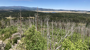
Big Lake Big View by chumley  Overview OverviewBig Lake Knoll is a small mountain that rises about 400 feet above the surrounding terrain about a mile and a half southeast of the popular Big Lake recreation area in eastern Arizona's White Mountains. A popular hiking trail leads to the summit and provides excellent views of the area. Trail #627A to the summit of the knoll is a spur off the longer Indian Spring Trail #627. It seems that this spur to the summit gets exponentially more use than the full loop trail and subsequently deserves its own description.
The description of this hike begins at the Indian Spring trailhead along Forest Road 249E. (For access from the nearby Big Lake campgrounds see the note below.) The hike starts by heading south on Indian Spring Trail #627 by meandering through open meadows and then groves of aspen and fir over rolling terrain with little elevation change. At 0.6 miles you'll reach the signed junction for the Knoll, pointing you toward the lookout tower that no longer stands at the summit. The spur begins a more noticeable climb, gaining 300 feet over half a mile, and going through areas of deadfall from the 2011 Wallow Fire which affected the area. Trail crews seem to keep up on things so the route is nicely cleared, but it wouldn't be surprising to find a tree or two laying across the trail that has fallen since the last visit by the chainsaws. If you're not accustomed to the elevation, even this short climb above 9,000 feet can make you gasp for oxygen! The route corkscrews around the east side of the knoll, topping out from the south at the end of the motor vehicle access road (yes, you can drive here too, but what fun is that?). Remnants from an old set of steps lead from the end of the road up the final few feet to the site of the old lookout tower. Looking closely, you'll see the remnants of the four steel posts that the Forest Service cut after the tower was irreparably damaged on June 4, 2011, in the Wallow Fire. The heat blew out the windows and there are remnants of broken glass and other old tower artifacts to be found nearby. A large electrical communication box now dominates the peak, but it's easy enough to get around it and take in the big views all around. There's no escaping the damage of the Wallow Fire, with large swaths of the White Mountains cleared of their former pine forest. To the northwest, Baldy Peak — Arizona's 2nd highest — rises to 11,403 feet, while to the east, the massive Escudilla Mountain dominates the horizon at over 10,800 feet, just a couple of miles from the New Mexico state line. On a clear day, you can see Mt. Graham, the 10,000+ foot sky island 85 miles to the south near Safford. After enjoying the views and maybe a snack or a picnic, head back the same way you came, retracing your steps back to the trailhead. Note There are no facilities along this hike. There's no water or restrooms at the trailhead or the summit. During Arizona's summer monsoon, it is common for thunderstorms to develop by late morning and continue throughout the day. Please be aware of potential storms and take appropriate precautions. Frequent lightning, high winds, and dangerous hail are all possibilities. Campground access to the hike While this hike is a 2.25-mile out-n-back route from the trailhead, developed spurs reach the trailhead directly from Loop D at the Rainbow Campground adding 0.45 miles each way (Trail #627C) and also an old two-track road from behind the Pine group site at Apache Trout Campground, adding 1.1 miles each way (trail not numbered). Check out the Official Route and Triplogs. Leave No Trace and +Add a Triplog after your hike to support this local community. | ||||||||||||||||||||||||||||||||||||||||||||||||||||||||||||||||||||||||||||||||||||||||||||||||||||||||||||||||||||||||||||||||||||||||||||||||||||||||||||||||||||||||||||||||||||||||||||||