Route Editor

| Guide | ♦ | 2 Triplogs | 0 Topics |
details | drive | no permit | forecast | 🔥 route |
stats |
photos | triplogs | topics | location |
| 18 | 2 | 0 |
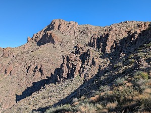
Simultaneous Views of Camelback Mountain and Peak by pseudalpine  Overview OverviewThis hike is a direct route from Fish Creek Canyon, most likely approached via the Tortilla TH and Lost Dutch. The mountain's west side is quite boring compared to this more challenging and interesting southern route. Hike About a mile upstream (east) from where Lost Dutch Canyon joins Fish Creek is a small ravine on the left (northeast). Bouldery at first and then scrambly through several red slabs up to where a massive white boulder is essentially plugging the wash. Past here and amongst some relatively smaller white boulders, find a way out of the ravine to the right and ascend the steep slopes to a scenic col. Continue east up steep Saguaro talus, aiming for the base of an obvious white buttress. There's a right-angled ledge (with a precariously protruding rock near the bottom) that can be carefully climbed over and up past a small tree. Traverse the ledge, then scramble yellow slabs to a gully system.
Synopsis Better summit views than Black Cross Butte 4806, but the official route is not an easy hike. There are at least three scrambling sections through cliff shelves where a tumble would definitely cause injury. This route would be treacherous if the area were wet with precipitation, especially when descending. Check out the Official Route and Triplogs. Leave No Trace and +Add a Triplog after your hike to support this local community. | |||||||||||||||||||||||||||||||||||||||||||||||||||||||||||||||||||||||||||||||||||||||||||||||||||||||||