Route Editor

| Guide | ♦ | 1 Triplog | 0 Topics |
details | drive | no permit | forecast | route |
stats |
photos | triplog | topics | location |
| 5 | 1 | 0 |
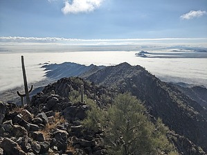
Seven Miles as the Hikebot Flies by pseudalpine  As FLYING_FLIVER succinctly describes in his Apr 04 2016, Sevenmile Mountain - Peak 2948 Triplog, this obvious and contorted mountain range is located NE of Rainbow Valley and SW of the Sierra Estrellas' prodigious southern terminus. I'd wager that when hikers drive Dead Cow Road (SR 238) between Maricopa and Gila Bend, they can't resist tracing an imaginary route across this choppy and worthy ridgeline that imperiously orientates itself northwest to southeast. I know I did, many times, on trips between Phoenix and San Diego over the last three decades. As FLYING_FLIVER succinctly describes in his Apr 04 2016, Sevenmile Mountain - Peak 2948 Triplog, this obvious and contorted mountain range is located NE of Rainbow Valley and SW of the Sierra Estrellas' prodigious southern terminus. I'd wager that when hikers drive Dead Cow Road (SR 238) between Maricopa and Gila Bend, they can't resist tracing an imaginary route across this choppy and worthy ridgeline that imperiously orientates itself northwest to southeast. I know I did, many times, on trips between Phoenix and San Diego over the last three decades.The Official Route begins on BLM land near where the transmission lines make a turn 45° from south to NW. This might be a safer parking area than illegally parking on sovereign Native American land. However, there is ample evidence of Second Amendment zealots frequenting this place (otherwise known as 2A idiots for the shooters that leave all their beer cans, casings, shells, and target trash behind). As with the approach drive, one must take responsibility for your actions and pick your poison. I chose to hike this loop counterclockwise for two main reasons, which were to keep the low, winter sun at my back and complete the difficult traverse earlier, rather than later. Road walking always seems easier at the end of the day and this track wasn't any different except for a few major wash crossings.
Check out the Official Route and Triplog. Leave No Trace and +Add a Triplog after your hike to support this local community. | |||||||||||||||||||||||||||||||||||||||||||||||||||||||||||||||||||||||||||||||||||||