Route Editor

| Guide | ♦ | 1 Triplog | 0 Topics |
details | drive | permit | forecast | route |
stats |
photos | triplog | topics | location |
| 40 | 1 | 0 |
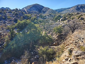
not the San Juan in Puerto Rico or in the South Mountains of Phoenix by Mike_W  Overview OverviewSan Juan Hill, at an elevation of 5269 feet, is one of the lower-elevation peaks in the Rincon mountains. This hike is a lot shorter and easier than many of the other huge Rincons peaks like Rincon Peak, Mica Mountain and Tanque Verde Peak. There is no trail but if you follow my route through the sandy rocky wide canyon and then up the ridgeline it is a pleasant hike. Note that there are many other bad ways to go for this hike. Some of the lower hillsides and narrow canyons are filled with catclaw bushes, but these are mostly avoided if you take my route. Hike From the parking area, walk roughly 500 feet South on the road and look for a cattle trail on the west side of the road. Follow the cattle trail(s) for roughly 500 feet. There's an intersection of 2 canyons in this area and your goal is to get into the canyon that heads west, not north. The canyon heading west will open up and have a lot of sandy areas and rocky areas, but it is fairly easy to navigate, for the most part. There will be some obstacles to go around, which is common with most canyons.
When I got higher up on the ridgeline I saw less catclaw bush and more oak, mesquite, manzanita, bear grass, and other non-thorny plants. When I hiked in early January, there was some snow cover higher up on the ridgeline but the snow wasn't slippery and there were patches of mossy plants in many areas. There were at least 2 rocky sections higher up on the ridgeline that were not trivial. You will need to weave around them. In one case I remember coming down through a rocky area and I needed to squeeze by a few dead oaks and some manzanitas. Eventually, you will make it to the summit and you should find a registry in a rock pile. From the summit, you should be able to see Rincon Peak to the northwest. Looking northeast you should be able to see Forest Hill and North Star peaks. Take the same route down and remember, staying on the ridgeline and wider sandier canyons will allow you to avoid most of the catclaw bush.
Check out the Official Route and Triplog. Leave No Trace and +Add a Triplog after your hike to support this local community. | |||||||||||||||||||||||||||||||||||||||||||||||||||||||||||||||||||||||||||||||||||||||||||||||