 Route Editor

| Guide | ♦ | 2 Triplogs | 0 Topics |
details | drive | no permit | forecast | route |
stats |
photos | triplogs | topics | location |
| 0 | 2 | 0 |
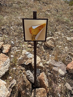
Butteless, BUT Various Peaks En Route by pseudalpine  Overview OverviewOne of the three main trails of the six named in the Casa Grande Mountain Park. This one boasts more sections of moderate (blue) difficulty than the West Butte Trail but isn't considered difficult (black) like over half of the Ridge Trail's implied metrics. Regardless, all three are similar in pleasant trail quality and the types of desert landscapes encountered. Hike The most likely start will be from the eastside Arica Road Trailhead. The first GPS tracked section of this trail doesn't match what is depicted on the provided maps, both online and posted at the trailhead signs. Simply heading west from the carpark, turning left at each of two initially encountered junctions will get you going south on the track that passes the B-7 EMS Marker. From this quarter-mile point, the route mostly matches what is portrayed. At about 0.44 miles is the major saddle junction where the route is an old road for a bit heading southeast. Quickly there'll be another junction where Social Trails Green 0.17 and 0.77 split right (south) but the most-traveled path switchbacks northeast and traverses around the north and east sides of Peak 1864 to another saddle junction (C-6 EMS Marker).
Synopsis Tracked at 2.54 total miles, this route doesn't match up with the 1.79 miles that are illustrated on the City of Casa Grande maps. Nevertheless, it's a gratifying walk that can be linked and looped with other salubrious trails in the park.
Check out the Official Route and Triplogs. Leave No Trace and +Add a Triplog after your hike to support this local community. One-Way Notice This hike is listed as One-Way. When hiking several trails on a single "hike", log it with a generic name that describes the hike. Then link the trails traveled, check out the example. | |||||||||||||||||||||||||||||||||||||||||||||||||||||||||||||||||||||||||||||||||||||||||


