 Route Editor

| Guide | ♦ | 3 Triplogs | 0 Topics |
details | drive | no permit | forecast | route |
stats |
photos | triplogs | topics | location |
| 27 | 3 | 0 |
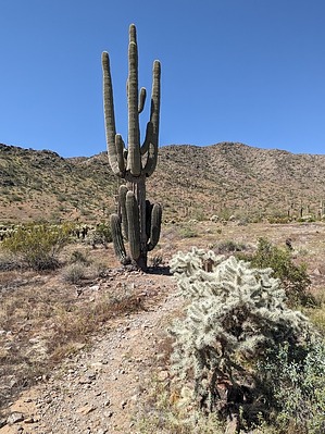
Bifurcated Semi-Loopy Prickler! by pseudalpine  Overview OverviewThis mostly easy-rated trail is divided into two parts: the northern track (black), capped by a mini lasso near the Ridge Trail and the shorter southern path (red) that is an alternate route to the main saddle junction south of the Arica Road TH. An out and back of both branches would be about five miles. Hike Starts at the north side of the carpark near the john (at least until it's moved). The beginning quarter mile involves two sweeping turns and then tees into the obvious north/south divergence. Bearing right, the trail goes almost directly north, transecting several washes for another half mile before traversing around Peak 1679. There's a road and two more major wash crossings as one heads northeast before reaching the small crowning loop at about 1.25 miles. Choose your circling direction, right or left, both cross another old road and briefly track the Ridge Trail concurrently for a bit. Perhaps return the same way so that you can complete the southern fork, which is very similar to the north section of the East Butte Trail.
Noisier than some of the other park trails because of its close proximity to the usually busy I-8 and I-10 intersection. Also namesaked fairly well as there are plenty of Sonoran Desert plants along the way with highly spiked exteriors. Of course, this route could be integrated into other longer loops involving some of the five other main Casa Grande Mountain Park trails.
Check out the Official Route and Triplogs. Leave No Trace and +Add a Triplog after your hike to support this local community. One-Way Notice This hike is listed as One-Way. When hiking several trails on a single "hike", log it with a generic name that describes the hike. Then link the trails traveled, check out the example. | |||||||||||||||||||||||||||||||||||||||||||||||||||||||||||||||||||||||||||||||||||||||||


