 Route Editor

| Guide | ♦ | 3 Triplogs | 0 Topics |
details | drive | no permit | forecast | route |
stats |
photos | triplogs | topics | location |
| 15 | 3 | 0 |
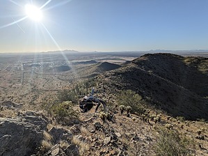
Perhaps You're "The One"? by pseudalpine  Overview OverviewThis hike is not a particularly complicated ridgeline as compared to some of the others near this area. e.g., Table Top and the South Maricopa Mountain Wildernesses. However, the common theme is the integration of several saddles, official benchmarks, and unlabeled highpoints on the Casa Grande Mountains ridgeline. Another amalgamation is the land use zones one must pass through to complete this hike, i.e., it starts and ends on private land, crosses Military- and City- owned properties, and skirts State Trust near the carpark. Because of this, hiking this track may not continue to be possible, as likely development occurs, and the sentinent Agents try their best to restrict the consumption of life-changing Redpills. Hike From the Radio Tower Trail parking, walk north on South Barstow Avenue. One may try and park at the official route's starting point (there is a littered turnabout), but I'd avoid that because it's private land. The second, most north ridge with the large CG white rock insignia is what you should be ascending. There's a subtle path wandering up the west side and over two of the northwestern hilltops. It isn't overly brushy and access to the Radio Tower Road saddle is possible without overly strenuous effort. Gap the gate and follow the upper section of the Casa Grande Mountains - 2350 route. The majority of this section has a well-beaten path, especially between 2332 Casa Grande 2 and Peak 2175. The path does peter out as one travels south.
Now that you've channeled your inner Neo, the obscure path can be deciphered with the help of a few actual large cairns. Near Peak 2175, there's a trail junction north down into a western side canyon. I'd avoid exploring that side of the ridge unless you really would like to practice more of your bullet-dodging skills. Continue southwest to Peak 2036 and then drop to an obvious saddle at the base of a quartz bluff. This would be a good bailout spot to the Ridge Trail, if there are a lot of shooters spraying away into the southwest side of the park. If you're able to finish the remaining ridge, descending south after Peak 1765 is an interesting quartz landscape with numerous and surprisingly beautiful Saguaros. From this road area at the south side of the range, one can walk Isom Road northwest, looping back to Hanna Road and the Radio Tower Road parking lot. Another option is to utilize your now bullet-ridden shuttle vehicle to drive back the same deproach. A final option is to complete a larger loop by integrating the many other east and north side Casa Grande Mountain Park trails to discover how deep the rabbit hole goes!?! Gate Policy: If a gate is closed upon arrival, leave it closed after you go through. If it is open, leave it open. Leaving a closed gate open may put cattle in danger. Closing an open gate may cut them off from water. Please be respectful, leave gates as found. The exception is signage on the gate directing you otherwise. Check out the Official Route and Triplogs. Leave No Trace and +Add a Triplog after your hike to support this local community. One-Way Notice This hike is listed as One-Way. When hiking several trails on a single "hike", log it with a generic name that describes the hike. Then link the trails traveled, check out the example. | |||||||||||||||||||||||||||||||||||||||||||||||||||||||||||||||||||||||||||||||||||||


