Route Editor

| Guide | ♦ | 1 Triplog | 0 Topics |
details | drive | permit | forecast | route |
stats |
photos | triplog | topics | location |
| 58 | 1 | 0 |
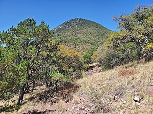
Drug traffickers hangout 4 miles North of the Mexican border! by Mike_W   Overview OverviewSutherland Peak, at an elevation of 7,262 feet, is a rugged peak that requires at least 3 miles of off-trail hiking. Most of the off-trail hiking has good use-trails, animal trails, and not a lot of brush if you go the right way. But, if you happen to get off the use-trails, the brush can get pretty rugged. Note that this peak is less than 4 air miles from the Mexican border. Warning I was told by a border patrol agent that I met near the trailhead for Bob Thompson Peak in June 2023 that Sutherland Peak was often used by "drug cartel scouts". I didn't let that deter me from hiking this peak, but please proceed with caution and it would be better if you hiked during the daytime and did not hike alone.
Walk North on FSR 4775, which may be unmarked (see my route), for 0.44 miles. Make a left at the junction on FSR 4776, which may also be unmarked. Continue until you have hiked a total of about 1 mile. You should see a sign telling you to go left for "Ida Canyon Trail No 110", and a few other points of interest. Take a left here and follow the trail up but you will only follow the trail for a short distance. Only follow the trail to this location: 31.389828, -110.327506. Once the trail turns and heads north, you will want to look for a use-trail heading west/southwest. There won't be a clearly defined trail, but rather a few ways to go where you can tell people or animals have been this way. If you see a canyon up ahead, you can follow it, keeping it on your left side. There was maybe 1 spot where the terrain outside the canyon was very rocky/rugged and the hiking was easier in the canyon, so I took the canyon for a short distance. Your goal is to make it to the saddle north of Sutherland Peak. From here there appear to be multiple use-trails going to the top of Sutherland Peak. The better route in my opinion was my route going up. You'll want to get onto the ridge northwest of the summit and take that ridgeline up. When you get to the high ridgeline it is fairly rocky and you will want to stay as close to the top of the ridgeline as you can. There are a few areas where the brush is too thick and you'll need to stay on the southwest (right) side of the ridgeline. I don't remember ever having to be on the left side of the ridgeline mainly because it was like a cliff on that side. At the peak, there were a few open areas and it was a nice looking summit with views of the high peaks in the Huachucas such as Miller Peak. I searched extensively and did not find a registry but I happened to bring a jar so I started a new registry. Then, I put it under a small rock pile at the high point. I also found several pairs of carpet shoes near the summit and some along the trail on the way down. There was definitely evidence of drug running in the past here. Not sure how old this activity was but the carpet shoes didn't look too old to me. Whenever you see carpet shoes anywhere, you know these people using them were absolute criminals and up to NO GOOD. On the way down, I had some extra time so I decided to explore around more. I followed a few different trails that seemed to dead-end in bad places. Not sure if these were anything more than animal trails. I also followed a trail that looked like it was heading down the east ridge but it faded away at a certain point and I decided to go back the way I came. If you happen to hike to this summit, please be aware of your surroundings and take caution. Check out the Official Route and Triplog. Note This is a moderately difficult hike. Leave No Trace and +Add a Triplog after your hike to support this local community. | |||||||||||||||||||||||||||||||||||||||||||||||||||||||||||||||||||||||||||||||||||||||||||||||||||