Route Editor

| Guide | ♦ | 63 Triplogs | 1 Topic |
details | drive | permit | forecast | 🔥 route |
stats |
photos | triplogs | topic | location |
| 631 | 63 | 1 |
One mile from Mexico! by brianb   Miller Peak, at 9466 feet, is the highest point in the Huachuca mountains - just a few miles from the Mexican border. Although the scenery along the way is not as spectacular as some other hikes in southern Arizona, the view from the summit is as far as the eye can see in all directions. And being so far south, the flora takes on a slightly more Mexican flavor. Miller Peak, at 9466 feet, is the highest point in the Huachuca mountains - just a few miles from the Mexican border. Although the scenery along the way is not as spectacular as some other hikes in southern Arizona, the view from the summit is as far as the eye can see in all directions. And being so far south, the flora takes on a slightly more Mexican flavor.This hike isn't at the very top of my list, but it's worth doing if you've 'been there and done that' everywhere else and want something new. There are a few other trails and peaks in the Huachucas, but if you're going to make the trip down there, I'd take this one, being the highest.
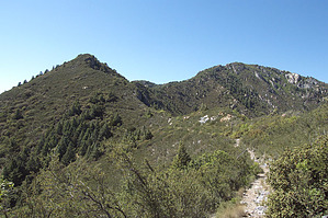
From the parking lot at the end of the long, winding gravel road, head straight across the road from the entrance to the lot and pick up the trail at the trail sign. The Crest Trail #103 begins from a rather scenic saddle on the south side of the range and proceeds through dry, grassy slopes punctuated with the biggest yucca and agave plants I've ever seen. Then you emerge on the other side of the mountain, almost in the blink of an eye, under a canopy of pine trees. The reddish gravel trail (which is well defined and easy to follow) proceeds steadily up along the upper sides of the valleys towards Miller Peak, offering many lovely views along the way. You'll wind your way amongst cacti, oak, pine, and aspens around the north side of the mountain and up towards the summit. There is only one real intersection to watch for - 1/2 mile from Miller peak, the trail splits off to your left (marked with plenty of signs) - follow the trail to the right up the last 1/2 mile to the summit. Enjoy the view and look around for the large clusters of ladybugs that frequent the summit.
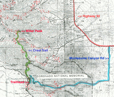
Coronado National Memorial NPS Details The trailhead is across the road at the northeast end of the Montezuma Pass parking area. The trail climbs for 2 miles to the northwestern boundary of the Memorial. There it enters Coronado National Forest and continues along the crest of the Huachuca Mountains to the turnoff for Miller Peak, the highest peak in the Huachucas. Check out the Official Route and Triplogs. Note This is a moderately difficult hike. Leave No Trace and +Add a Triplog after your hike to support this local community. | |||||||||||||||||||||||||||||||||||||||||||||||||||||||||||||||||||||||||||||||||||||||||||||||||||||||||||||||||||||||||||||||||||||||||||||||||||||||||||||||||||||||||||||||||||||||||||||||||||||||||||||||||||||||||||||||||