 Route Editor

| Guide | ♦ | 1 Triplog | 0 Topics |
details | drive | permit | forecast | route |
stats |
photos | triplog | topics | location |
| 25 | 1 | 0 |
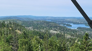
Trek to the Tower by The_Eagle Starting at the Rock Harbor Trail at the Dairy Farm Campground, you will climb 650 feet to the mothballed fire tower.
The trail eventually leads you to the summit of Mt. Ojibway, which stands at 1,132 feet above sea level. At the top, you’ll find the historic fire tower, built in the 1930s. This fire tower was once used to spot wildfires across the island, a crucial task in an area prone to lightning strikes and dry conditions. The views from Mt. Ojibway are stunning, with sweeping vistas of the island’s interior and Lake Superior and Canada. The trail intersects the Greenstone Ridge Trail where you have other hiking opportunities. Check out the Official Route and Triplog. Leave No Trace and +Add a Triplog after your hike to support this local community. One-Way Notice This hike is listed as One-Way. When hiking several trails on a single "hike", log it with a generic name that describes the hike. Then link the trails traveled, check out the example. | ||||||||||||||||||||||||||||||||||||||||||||||||||||||||||||||||||||||||||||||||||||||||||


