Starting just west of Sycamore Campground on Turkey Creek Road, this trail heads up forested Pole Bridge Canyon to connect with the Turtle Mountain Trail #219 and the Morse Canyon Trail #43, near 8850 foot Johnson Peak. An 8-mile loop is possible using the Pole Bridge Trail, Morse Canyon Trail, and about a mile and a half of Forest Road 41 (Turkey Creek Road).
When hiking several trails on a single "hike", log it with a generic name that describes the hike. Then link the trails traveled, check out the example.
WARNING! Hiking and outdoor related sports can be dangerous. Be responsible and prepare for the trip. Study the area you are entering and plan accordingly. Dress for the current and unexpected weather changes. Take plenty of water. Never go alone. Make an itinerary with your plan(s), route(s), destination(s) and expected return time. Give your itinerary to trusted family and/or friends.
Permit $$
None
Coronado Forest MVUMs are rarely necessary to review unless mentioned in the description or directions Coronado Motor Vehicle Use Maps (MVUMs)
Directions
Road
FR / Jeep Road - Car possible when dry
To hike From Tucson, take I-10 east for 72 miles to US 191. Turn south 21 miles to AZ 181 and drive 12 miles east to the Turkey Creek turnoff (FR 41). Follow this road 10 miles east to the Pole Bridge Trail sign on the right (south) side of the road (0.2 miles before Sycamore Campground, where one can park).
page created by PrestonSands on Oct 08 2009 12:27 am
 Route Editor


 Starting just west of Sycamore Campground on Turkey Creek Road, this trail heads up forested Pole Bridge Canyon to connect with the Turtle Mountain Trail #219 and the Morse Canyon Trail #43, near 8850 foot Johnson Peak. An 8-mile loop is possible using the Pole Bridge Trail, Morse Canyon Trail, and about a mile and a half of Forest Road 41 (Turkey Creek Road).
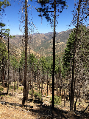


