 Route Editor

| Guide | ♦ | 2 Triplogs | 0 Topics |
details | drive | no permit | forecast | map |
stats |
photos | triplogs | topics | location |
| 33 | 2 | 0 |
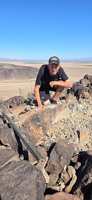
 Overview OverviewEasily accessible slender basalt-peppered mini-peak from multiple origins, arguably a butte. Nearby Bunyan Peak, Woolsey Peak nearly obscurring the perfect ridge to 2283, the I-10 showstopper Saddle Mountain and Face Mountain steal the show. Davis offers a unique view of all, rounding out the 360° view with an Eagletail Mountains grand finally to the NW.
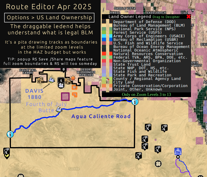
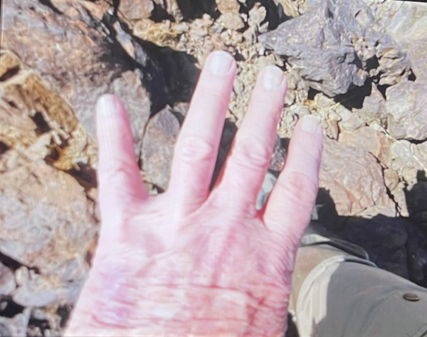
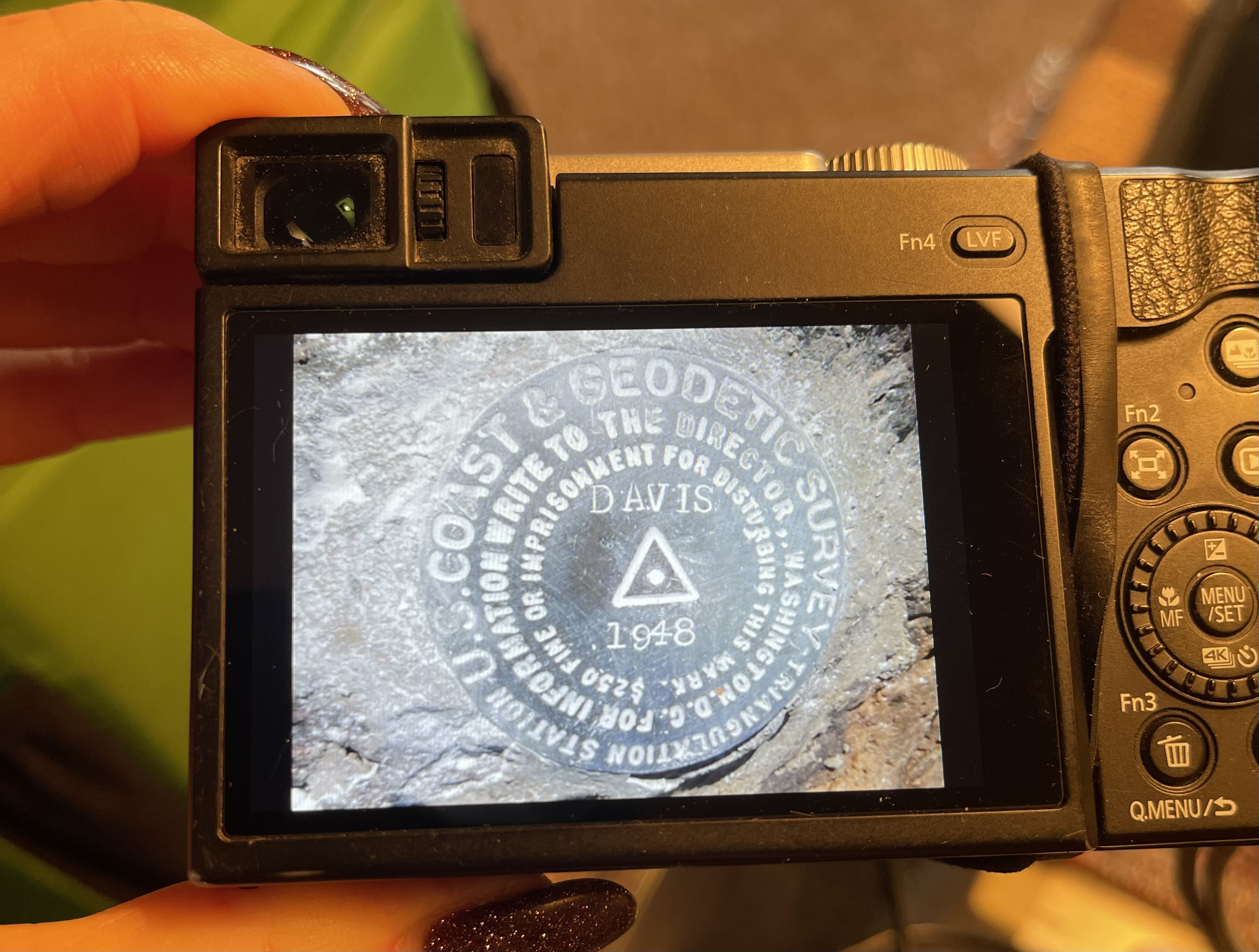
The benchmark, DAVIS 1880 noted as a triangle on topo along with Davis Well were undoubtedly named along with the seemingly long gone Davis Ranch. Approach The approach is arbitrary. None are difficult. If you can't figure out Route Editor or mapping software of your choice, then hikes like this may not be your calling. You need to know land ownership[1] to utilize BLM access and travel. Agua Caliente Road to Fourth of July Butte looks to be the 100% legal no-hassle route. I opted for a north approach from Dobbins Rd since I wasn't sure about the road with my bicycle grade tires. 499th Ave ending at Owl Butte appears to get you within a stone's throw of 1880. Especially if you continue along Arlington Clanton Well Rd(notable path). I didn't figure that out until later. That would be a short 2.5-mi RT hike. If possible, you could knock out Owl/Davis/4th and/or other nearby peaks to make the drive worthy. We almost started halfway to Saddle Mountain. Hike The hike across the desert from wherever you start is easy travel. Broken antique(ish) glass of all sorts stands the test of time in areas but it's not eyesore level in this old state/quantity. Post-holing can catch you off guard so keep an eye on critter tunnels and the general aerated soil in areas. Creosote Bush is minimal at best except in major washes such as Centennial Wash and its tributaries in our route. The ascent up to 1880 is the fun part. The grade increases from casual to "this looks best" to "is this safe" as you go up. Basalt is the game and was more stable than I expected. Ocotillo would be dangerous if you lose your footing. 1880 itself is easy to locate. The top has a few nice large flat enough rocks to enjoy a break pondering the views. The descent was slow with my three points of contact but quicker than anticipated, Final FLIVER FLIVER's family contacted me on March 30th with the sad news he never returned home from this disc hunt, he had enough supplies to last 3 days in the desert (just in case!). Initial contact excert ...after an extensive helicopter search and many hours, they found him deceased. He was a VERY healthy guy and the autopsy has ruled out any heart attack, aneurism, and stroke. Homicide is also ruled out. ... PS…he loves the HikeAZ site and he wears his shirt from the site proudly. My initial reply: Davis Benchmark is a small summit on the Phoenix District BLM(Bureau of Land Management). Most are familiar with the Forest Service (FS). BLM is typically rangeland, which is the case in this location surrounded by farming. Albeit small it is steep! The two popular peaks in the Phoenix metro area are Camelback & Piestewa. These are considered steep @ 21% & 20% grades. While the Davis ascent is a third less elevation than those, it is a whopping 40% grade(to my surprise, I've hiked Piestewa 5k times including twice today). There is no trail. The term "Davis Benchmark" refers to a tiny benchmark disc the USGS placed long ago for mapping in the old days. blah blah blah... This is the type of hike where you park as close as publicly possible, then walk across the open range. Based on the starting point and the destination, this was a flat off-trail hike for 2/3'rds of the hike. An autopsy would have revealed my speculations. HikeArizona.COM / hikeaz.com is a community of about 80k users. Sorry, I don't think I knew your father but admire his ambition. I believe there is a Facebook or such type of group that goes by HikeAZ too but I'm not familiar with social groups. When FLIVER joined HAZ, I was younger and cracking whips to keep the intense traffic in line. FLIVER didn't catch my attention until a triplog or two. His all-caps screen name had me itching to override. I read a triplog. Then another. I didn't know the man's name until two weeks ago, but I knew he had an intriguing twist and it fit the purpose of HAZ. He understood paragraphs... okay, he gets a soft pass. Boy howdy was that a good decision. Perhaps 5 years later, I learned benchmark names are stamped in all-caps. Dixie says it best. "He and I hiked to many of the same peaks, although for different reasons.". FLIVER jargon gelled in the community and he gained an elusive HAZ term created by the guy who created the name Route Scout for our crappy app that consumes the lion's share of my coding hobby. Aside from his superior disc knowledge, we gained hints of other hobbies of passion and the origin of his screen name. several replies later ... Please know the site was my dad’s favorite. He lived in Fountain Hills and did hikes all over AZ and logged them on the site with the name of FLYING_FLIVER. Most of my relatives from my parents up have passed. Unless you have no soul there are emotions. Dad wiped out a good week. Reading the above line, I came unglued. The effort to write is time-consuming when on topic. Well aware. If writing or deciphering elements of a hike doesn't hold your attention. Sprinkle your like-bait gently and consider turning off comments. Composing/posting genuinely applicable content without recognition is rough. Compounded with others raking in interactions on nonsense. He always talked about how much he looked forward to posting his hikes and pictures. The two days after a long hike, he would spend time cropping pictures and organizing everything. He also would take a bunch of pictures on the hike and then would take a picture of his hand holding up one finger, then the next group of pictures would be separated by a picture of his two fingers, etc. so he could easily group the pics on your site when he posted them. Looking at his camera, only got to #4 on that hike. FLIVER got the disc photo and one beauty of a last look. FLYING_FLIVER was among the most respectable multifaceted-contributing members to ever grace the pages of HAZ, he is irreplaceable. References
Check out the Triplogs. Leave No Trace and +Add a Triplog after your hike to support this local community. | ||||||||||||||||||||||||||||||||||||||||||||||||||||||||||||||||||||||||


