This is a very popular hike and a great teaser for what the Santa Catalinas of Tucson have to offer. This would be a great introduction for anyone visiting the area and willing to spend a day exploring. So if your friends didn't run screaming for the Winnebago after the Arizona-Sonora Desert Museum, take them to Hutch's Pool, just about anytime except monsoon season. Most people will find summer too hot for this hike, though. Try anytime from October through April. Hutch's Pool is full enough to swim all year, with a sandy beach and great views up canyon. This is a short hike, but take your time and keep your eyes open for fun. If you're lucky enough to see a fox, just sit still and enjoy watching it watching you.
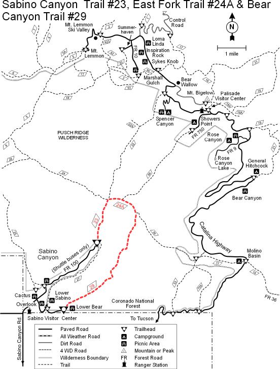
The trailhead is at the end of the paved road in Sabino Canyon in the Sabino Canyon Recreation Area. That means that if you want to get there before the (other) tourists, you need to get an early start to beat the trams. You can walk up the road, which will add almost four miles each way, or you can take the Phoneline trail which will add a little more. If you don't mind sharing, taking the tram up is an option. If you have friends or family visiting, you can actually use the tram ride to gauge their interest in seeing what lies beyond.
Where the road ends, link up with the Sabino Canyon Trail. Follow this about 2.5 miles to Sabino Basin. Enjoy the views of Sabino Creek along the way. From Sabino Basin, take the West Fork Trail, which will be clearly marked. These are well maintained trails. About one and a half miles along the West Fork Trail, you will find Hutch's Pool. As you're lounging on the beach, note the high-water mark and contemplate the amount of water that must move through here during monsoon season. Some seem to think this is a great place to share a -- ahem! -- private moment with their significant other. I cannot overemphasize that this is a very popular and well traveled spot.
WARNING! Hiking and outdoor related sports can be dangerous. Be responsible and prepare for the trip. Study the area you are entering and plan accordingly. Dress for the current and unexpected weather changes. Take plenty of water. Never go alone. Make an itinerary with your plan(s), route(s), destination(s) and expected return time. Give your itinerary to trusted family and/or friends.
Four specific day-use areas require a Coronado Recreational Pass or a National Pass/America the Beautiful Pass.
1) Sabino Canyon - located on the Santa Catalina Ranger District (520)749-8700
2) Madera Canyon - located on the Nogales Ranger District (520)281-2296
3) Cave Creek - located on the Douglas Ranger District (520)364-3468
4) Mt. Lemmon at 11 day-use sites.
2025Catalina State Park
Per vehicle (1 person): $10.00
Per vehicle (2-4 people): $20.00
Individual/bicycle: $5.00
Coronado Forest MVUMs are rarely necessary to review unless mentioned in the description or directions Coronado Motor Vehicle Use Maps (MVUMs)
Directions
Road
Paved - Car Okay
To Sabino Canyon Recreation Trailhead From the intersection of Tanque Verde and Grant/Kolb Rd head northeast on Tanque Verde. Turn left at the second light on Sabino Canyon Rd. Go about 8 miles up Sabino Canyon Rd and you come to a four way stop with Sunrise. Go straight through the intersection and take the next right into the parking lot of Sabino Canyon Recreation Area. Signs marking the way start on North Kolb road.
This is the universal directions to Sabino Canyon Recreation Center. Hikes take off from all directions and some you might need to hike another trail to get to the start of your hike. Reference the hike summary for details.
From PHX (I-10 & AZ-51) 117 mi - about 1 hour 57 mins From TUC (Jct 1-10 & Grant) 14.1 mi - about 30 mins From FLG (Jct I-17 & I-40) 261 mi - about 4 hours 1 min
 Route Editor


 This is a very popular hike and a great teaser for what the Santa Catalinas of Tucson have to offer. This would be a great introduction for anyone visiting the area and willing to spend a day exploring. So if your friends didn't run screaming for the Winnebago after the Arizona-Sonora Desert Museum, take them to Hutch's Pool, just about anytime except monsoon season. Most people will find summer too hot for this hike, though. Try anytime from October through April. Hutch's Pool is full enough to swim all year, with a sandy beach and great views up canyon. This is a short hike, but take your time and keep your eyes open for fun. If you're lucky enough to see a fox, just sit still and enjoy watching it watching you.
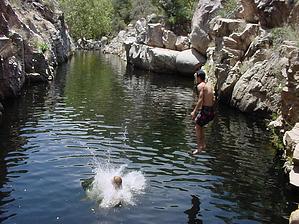


