Grand Canyon - Inner Gorge - AZT #38, AZ | HikeArizona
   🔥

Grand Canyon - Inner Gorge - AZT #38, AZ

Guide 48 Triplogs Mine 0 1 Topic
 
4.8 of 5 
Fav
Wish
0
details
drive
permit
forecast
🔥
route  
stats
photos
triplogs
topic
location
559 48 1
Statistics
tap icons for details
Difficulty 5 of 5
Route Finding 1 of 5
Distance One Way 20.5 miles
Trailhead Elevation 7,207 feet
Elevation Gain 5,803 feet
Accumulated Gain 6,688 feet
Avg Time One Way 8-12 hours
Kokopelli Seeds 42.79
 Backpack Yes & Connecting
 Dogs not allowed
feature photo
Photos Viewed All MineFollowing
Inaugural Calculation on Button Tap!
8  2021-05-16
Grand Canyon Corridor Loop
survivordude
11  2019-10-07
Rim to Rim
Hippy
57  2019-07-04
AZT Utah to South Rim Grand Canyon
BiFrost
1  2019-05-18
Grand Canyon Corridor Loop
survivordude
14  2017-05-13 pjhikes
23  2016-10-21 WanderingWildcat
25  2016-06-01
AZT: Mormon Lake to Utah
DallinW
20  2015-09-05
Rim to Rim
BiFrost
Page 1,  2,  3
Author
author avatar Guides 16,881
Routes 17,283
Photos 24
Trips 1 map ( 6 miles )
Age 26 Male Gender
Location HAZ, TrailDEX
Associated Areas
list map done
Northwest Region
Historical Weather
Trailhead Forecast
Radar Map
Expand Map
Preferred Jul, Jun, Aug, Sep
Sun  6:59am - 6:23pm
Official Route
 
7 Alternative
 
 Water
Historic Fire Perimeteracres
🔥 2005 DRAGON CLX Fire19.4 mi*
Nearby Area Water
[ View More! ]
Fauna  Nearby
Flora  Nearby
Geology  Nearby
Meteorology  Nearby
Named place  Nearby
Culture  Nearby
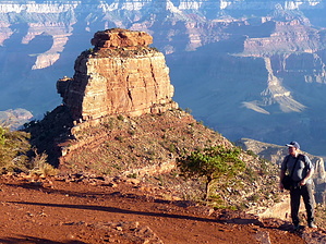
Natural Wonder - Give it a Whirl
by HAZ_Hikebot

Overview
This passage begins at the South Kaibab Trailhead on the South Rim of the Grand Canyon. The trail descends through switchbacks, runs north below Yaki Point, along Cedar Ridge, and then reaches the Cedar Ridge rest area. The trail continues down along Cedar Ridge, passes on the east side of O'Neill Butte, and then switchbacks down the east side of a large butte and curves back around to the north. It comes to the Tonto Trail junction and continues across the Tonto Plateau to the edge at a place called The Tipoff. The trail now drops into the inner gorge and switchbacks down to a tunnel and then a suspension bridge across the Colorado River. On the other side, the trail heads downstream, passing the boat beach. It leaves the river, turns north at Bright Angel Creek, and passes Bright Angel Campground. After passing through Phantom Ranch, the trail becomes the North Kaibab Trail, and it continues following Bright Angel Creek. It passes the junction with the Clear Creek Trail, enters the narrows of Bright Angel Creek, and passes Phantom Canyon. The trail crosses the creek several times on footbridges and then reaches the junction with the trail to Ribbon Falls. From the falls, the trail continues up along the creek and reaches Cottonwood Camp.
Further upstream, the trail crosses the creek for the last time and comes to a rest house. It passes the turnoff to Roaring Springs and then begins climbing up along Roaring Springs Canyon. There is a bridge over this creek and then a tunnel. A final set of switchbacks are passed through, and then the trail reaches the North Kaibab Trailhead.

Southern Trailhead: South Kaibab TH - Hwy 64

Northern Trailhead: North Kaibab TH - HWY 67

Recommended reading
South Kaibab, North Kaibab

Check out the Official Route and Triplogs.

Note
This is a difficult hike. It would be insane to attempt this entire hike without prior experience hiking.

Leave No Trace and +Add a Triplog after your hike to support this local community.

2018-07-14 HAZ_Hikebot
  • Grand Canyon Use Area Boundaries - Dynamic Map

One-Way Notice
This hike is listed as One-Way.

When hiking several trails on a single "hike", log it with a generic name that describes the hike. Then link the trails traveled, check out the example.
WARNING! Hiking and outdoor related sports can be dangerous. Be responsible and prepare for the trip. Study the area you are entering and plan accordingly. Dress for the current and unexpected weather changes. Take plenty of water. Never go alone. Make an itinerary with your plan(s), route(s), destination(s) and expected return time. Give your itinerary to trusted family and/or friends.

 Permit $$
NPS

Grand Canyon National Park
Details for each are occasionaly below numerous alerts
Entrance Fee
Overnight/Backpacking Permits
Grand Canyon Use Areas Map
Rim-to-Rim and Extended Day Hike/Run


 Directions
or
or
 Road


To South Kaibab Trailhead
From Flagstaff head west on I-40 for 30.4 mi to SR-64. Turn right/north and follow SR-64 55 miles to the park. You will receive a map & information at the GC park entrance.

You can only reach the trailhead by free-shuttle or taxi. Parking is available at several lots. There is a lot a mile from the trailhead on the east drive. If you are there early you can use this lot (it fills up fast) and hike the two miles there and back.

Express hikers' shuttles directly from Bright Angel Lodge and the Backcountry Information Center to the South Kaibab trailhead depart daily at:
March 7:00 a.m., 8:00 a.m., and 9:00 a.m.
April 6:00 a.m., 7:00 a.m., and 8:00 a.m.
May 5:00 a.m., 6:00 a.m., and 7:00 a.m.

NPS Note: The South Kaibab Trail is located near Yaki Point. Due to the popularity of this area and extremely limited space, parking is not permitted at the trailhead. Hikers must use the park's free shuttle bus system to reach the trailhead. Every morning, several hiker express buses leave from the Bright Angel Lodge and then from the Backcountry Information Center (times vary depending on the month). Otherwise, hikers will need to take the village bus (Blue Line) to Canyon View Information Plaza and transfer to the Green Line. South Kaibab trailhead is the first stop on the Green Line.

From PHX (I-10 & AZ-51) 235 mi - about 3 hours 42 mins
From TUC (Jct 1-10 & Grant) 340 mi - about 5 hours 12 mins
From FLG (Jct I-17 & I-40) 88.1 mi - about 1 hour 33 mins
page created by joebartels on Jan 09 2010 12:41 am
helpcorrectionissue

end of page marker