 Route Editor

| Guide | ♦ | 301 Triplogs | 11 Topics |
details | drive | permit | forecast | 🔥 route |
stats |
photos | triplogs | topics | location |
| 2.2k | 301 | 11 |
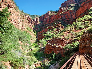
True Experience by HAZ_Hikebot  History HistoryThe North Kaibab Trail is the least visited but most difficult of the three maintained trails at Grand Canyon National Park. Almost a thousand feet higher at the trailhead than South Rim trails, hikers on the North Kaibab Trail pass through every ecosystem to be found between Canada and Mexico. At the rim, hikers will glimpse the vast maw of Bright Angel Canyon through fir trees and aspen, ferns, and wildflowers. The trail as it descends through the Redwall Limestone is blasted directly into the cliff, "literally hewn from solid rock in half-tunnel sections." Farther down, the ecology progresses so that hikers look up at the surrounding canyon walls through a blend of riparian and desert vegetation. Along the way, Roaring Springs and Ribbon Falls both offer rewarding side trips that are wonderfully juxtaposed to the often hot conditions of the main trail. Built throughout the 1920s to match the quality and grade of the South Kaibab Trail, the present-day North Kaibab Trail replaced an older route infamous for crossing Bright Angel Creek 94 times (the present-day trail crosses only six times). Even though it is a masterfully constructed and maintained trail, don't be deceived by the apparent ease and convenience of hiking it; from beginning to end, the North Kaibab Trail has its challenges.
Resembling the Bright Angel Trail more than the South Kaibab Trail, the North Kaibab initially descends steeply down the head of a valley via a series of numerous switchbacks. After the lush verdancy and impressive views below the trailhead, the trail reaches the distinctive Supai Tunnel, where hikers will find potable water (mid-May to mid-October) and pit toilets, but no emergency phone. Switchbacks continue to the massive cliffs of Redwall Limestone, where the trail has been blasted out of the cliff in a half tunnel for long stretches. The Redwall section is awe-inspiring in every way; fantastic exposure and views mingle with a reminiscence of an age when engineering marvels were commonplace. Where the bulk of the trail's descent meets the flatter bottom of Bright Angel Canyon, Roaring Springs is a worthwhile side trip. Here, water gushes forth directly out of the cliffs, cascading over moss and fern to form Bright Angel Creek (which will be a constant companion all the way to the Colorado River). This giant spring provides drinking water for every visitor and resident within Grand Canyon National Park. The water is delivered to the South Rim via a pipeline buried beneath the North Kaibab Trail (installed 1965- 1970). You can see this amazing pipeline as it stretches across the Colorado River on the underside of the Bright Angel Trail's Silver Bridge. At mile 4.7, an unexpected house comes into view. The Pumphouse Residence, also known as the Aiken Residence, is where artist and park employee Bruce Aiken lived and painted for decades. In years past, the lucky hiker could get a refreshing cup of lemonade from one of the Aiken kids raised at the bottom of the Grand Canyon. Passing the Pumphouse Residence is a welcome sign for the descending backpacker, for it signals the approach of Cottonwood Campground. Those fortunate to overnight at Cottonwood Campground will have the time to explore a beautiful oasis located 1.6 miles down-creek from the campground: Ribbon Falls is a true gem of the North Kaibab Trail. The waterfall is located in a grotto on the west side of Bright Angel Creek, so reaching it is a short but enriching side trip. Hikers caught in the heat of the day should consider taking a siesta here from 10 a.m. to 4 p.m. Between Cottonwood Campground and Bright Angel Campground, the trail enters the Inner Gorge, a narrow canyon within the canyon where the trail is boxed in on either side by 1.7 billion-year-old Vishnu Schist (the contact between the top of the Vishnu Schist and the overlying Tapeats Sandstone marks the Great Unconformity where over 1 billion years of geology is missing). Though the trail here is not challenging from the perspective of elevation profile, be aware that this is a dangerous stretch of trail during the summer months. Because the entire 7.2-mile stretch is at a low elevation, it becomes scorching hot from early morning to late afternoon. The gorge of black rock through which the trail passes becomes like an oven and can be compared to walking through a parking lot in Phoenix or Las Vegas in the summertime. Always plan on reaching Bright Angel Campground before ten in the morning. Important Notes Grand Canyon is, above all else, a place of extremes. Therefore, it is necessary to take appropriate precautions depending on seasonal variations in trail conditions. During the deep winter months, the upper section of the trail in Roaring Springs Canyon can be ice-covered and perpetually snowbound. On the North Rim, hikers need to be prepared for extreme winter conditions. During the hotter months, which can begin as early as May and last through September, it is critical that hikers have the discipline to begin their hike well before dawn or after 3 p.m. Success and enjoyment really depend on the amount of time spent in the Plan Ahead and Prepare stage (Leave No Trace). Success in the summer can be as simple as staying off the trail and out of the sun between 10 a.m. and 4 p.m. Hiking the entire North Kaibab Trail in a single day is not recommended, particularly in summer, as it is nearly impossible to avoid hiking in the heat of the day. Water Sources Potable water is available at the trailhead, Supai Tunnel, Roaring Springs, the Pumphouse Residence, Cottonwood Campground, and Bright Angel Campground. All except Bright Angel Campground are seasonal only and are turned off in the fall (exact dates vary; because each station's dates depend on temperatures, the rim and Supai Tunnel are turned off first). Please note that due to random acts of erosion causing pipeline breaks, potable water stations should be considered a gift and not relied upon. Check trailhead signage before descending and always bring an alternative and lightweight form of water treatment. From Roaring Springs to the Colorado River, the trail is never far from water that can be filtered or treated with chemicals. Campsites At-large camping is not permitted on the North Kaibab Trail; visitors must camp in designated campgrounds: Cottonwood Campground (CCG) located near the trail's halfway point 7 miles from the North Kaibab trailhead, or Bright Angel Campground (CBG) located immediately adjacent to the Colorado River at the bottom of the canyon and 14 miles from the North Kaibab trailhead. 2m 11s Video
Check out the Official Route and Triplogs. Note This is a moderately difficult hike. Leave No Trace and +Add a Triplog after your hike to support this local community. One-Way Notice This hike is listed as One-Way. When hiking several trails on a single "hike", log it with a generic name that describes the hike. Then link the trails traveled, check out the example. | |||||||||||||||||||||||||||||||||||||||||||||||||||||||||||||||||||||||||||||||||||||||||||||||||||||||||||||||||||||||||||||||||||||||||||||||||||||||||||||||||||||||||||||||||||||||||||||||||


