I must admit, this area didn't appeal to me until just recently. The drought of 2002 has forced most of the forest to close. I've mountain biked the area extensively years ago. That's before I gave up mountain biking to keep the blood "in" my body. Not to mention I'm writing this up in June when any sane individual would pass on a Phoenix hike. But you know, when the cards are down, go with what you have. So I headed out at 4:30 am two mornings in a row to capture my take on Hidden Valley from the Marco de Niza Trailhead!
Maybe you're reading this in the winter, thinking what's the big deal. Well, on this day, for instance, it's going to be 110 degrees in Phoenix. Probably with 7% humidity. The general idea in the summer is to bail big time and hit the pines! Since that isn't possible this year, I'm offering my take on the next best thing without racking up 300 miles in the car. As I said, I did this two mornings in a row. Not because I had to, just because it was so friggin cool the first time I had to do it again! No kidding! The key is the EARLY start. Yes, way before the sun kisses the Sonoran Desert.
From the Marcos De Niza Trailhead ( now new Pima Canyon ), head out on the dirt road into Pima Canyon. It's 1.1 miles and 175 elevation gain down the road to ( old ) Pima Canyon Trailhead. Apparently, long ago, you could drive to Pima Canyon Trailhead. That's a thing of the past. I'm sure they had problems with parties at night as it is well hidden from the surrounding city. No biggie, it's a pleasant walk. In fact, I'd call it one of the best mixtures of company in the valley. You have all the age ranges. Then you mix in hikers, joggers & mountain bikers. Add all that into one densely populated section of Phoenix, and there you have it.
The trail curves around before dipping into a wash marking the "official" start of the National Trail. If you started at 4:30 am in June as I did, you're still ahead of the daily sunrise. It wasn't "dark" up until this point either, just no sunshine. I'll add on that it's mighty refreshing too. Whoohoo! - Summertime chills in the desert! As with any morning hike, the company is top-notch. Probably an 80% "hello" rate. Anyhow... immediately onto the National Trail, you're gaining elevation. It's not much of a push gaining the final 550 feet in elevation, but you'll notice it here. In fact, it's enough to make most mountain bikers take the easier Mormon Trail up the mountain.
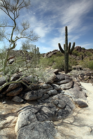
As you gain elevation, you're greeted by a wonderful sunrise. In June, the sun was nudging the Four Peaks' southernmost peak as it rose from the horizon. What makes this early morning hike so magnificent are the shadows. The trail is lined with many blackened boulders and weaves about. Keep in mind this is major mountain biking terrain. However, an early start puts you ahead of the game. I didn't pass one mountain biker until the return trip. This stretch between Pima Canyon Trailhead to the Hidden valley turnoff is 1.35 miles. The grade is moderate, averaging 13% for the most part. One short section is steep at 31%, which you can't imagine a bicycle going up, but they do! I tried for years, but it was too much for me.
At the Hidden Valley turnoff, you'll travel 0.45 miles through Hidden Valley. Which is really a shortcut cause it's 0.6 miles back on the National Trail to the same point. Okay, onto Hidden Valley Trail. You'll immediately pass through the tunnel. Now you're truly in a valley hidden from the surrounding city. This short stretch is gold in my book. Boulders that appear to be huge shaved off wafers and such are scattered about in addition to some interesting sculptures. Not likely on your trip, but shortly after the tunnel, I encountered a huge gathering of bees on the side of a rock.
The trail may be tricky to navigate your first few times through Hidden Valley. Not to worry, you won't really get lost. Once after rain, I've been up here, and let me tell you, this place turns into a playground. Since I got an early start this time out, the sun was just piercing into Hidden Valley. I lucked out, taking a photo. A hummingbird zipped right by, and I caught him in a photo about two feet away. You'll need to negotiate two rock slides along the way before reaching Fat Man's Pass, originally called "Wonder Rift" on early topo maps. Which is an amazing curvature of rock with the slightest gap throughout. From there, it's back home on the National Trail. Before reaching the Hidden Valley turn, you originally took, you'll pass the Mormon turnoff. You could take a variation back home.
WARNING! Hiking and outdoor related sports can be dangerous. Be responsible and prepare for the trip. Study the area you are entering and plan accordingly. Dress for the current and unexpected weather changes. Take plenty of water. Never go alone. Make an itinerary with your plan(s), route(s), destination(s) and expected return time. Give your itinerary to trusted family and/or friends.
Permit $$
None
Directions
Road
Paved - Car Okay
To Pima Canyon Trailhead To Pima Canyon Trailhead
This one is a little tough to locate if you're not from the area. It's near Guadalupe Rd. The issue at hand is there are no on-off ramps for Guadalupe Rd. Instead, get off south a mile on Elliot and follow 48th Street north.
Pima Canyon Trailhead is located west off of 48th Street, just south of Guadalupe Road. It's all somewhat confusing. Your first time, go to the intersection of Guadalupe & 48th, then head south. Take the first right and an immediate left into South Mountain/Phx Preserves Park. Follow the access road passing the golf course all the way to the trailhead.
Pima Canyon Trailhead and Marcos de Niza Trailhead are the same now. Long ago, the road continued to Pima Canyon Trailhead.
From PHX (I-10 & AZ-51) 10.9 mi - about 18 mins From TUC (Jct 1-10 & Grant) 101 mi - about 1 hour 32 mins From FLG (Jct I-17 & I-40) 155 mi - about 2 hours 25 mins
 Route Editor

 I must admit, this area didn't appeal to me until just recently. The drought of 2002 has forced most of the forest to close. I've mountain biked the area extensively years ago. That's before I gave up mountain biking to keep the blood "in" my body. Not to mention I'm writing this up in June when any sane individual would pass on a Phoenix hike. But you know, when the cards are down, go with what you have. So I headed out at 4:30 am two mornings in a row to capture my take on Hidden Valley from the Marco de Niza Trailhead!