 Route Editor

| Guide | ♦ | 39 Triplogs | 0 Topics |
details | drive | permit | forecast | route |
stats |
photos | triplogs | topics | location |
| 557 | 39 | 0 |
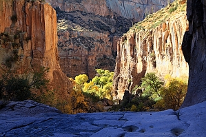
 GET Segment 7 overview GET Segment 7 overviewAravaipa might well be considered Arizona's "Grand Canyon of the Sonoran Desert." For like its neighbor to the north, Aravaipa Canyon is also a place born of water, uplift, and erosion - a great curving and carving of the land into a sheer-walled labyrinth of light and color, liquid and life. In terms of geography, this grand canyon is small - a fifth as high, its main passage walkable in just a day or two. Yet by the measure of its life, Aravaipa is a place of rare grandeur. Its perennial creek, fed by subterranean waters from past Ice Ages, harbors more native species of fish than any low country stream in Arizona. Aravaipa Creek and its tributaries nurture some 1000 acres of diverse, deciduous riparian forest. Mountain lion and bobcat hunt here, their prey including bighorn sheep, javelina, and coatimundi, in addition to white tailed deer. One hundred and fifty species of birds have been recorded in the canyon, including the large, unmistakable Great Blue Heron, a common and striking sight in this desert land. For just beyond the leafy shade at creekside, the saguaros, chollas, and prickly pear of the Sonoran Desert take hold once more, clinging to buff-brown slopes worn sheer by the work of time. The above synopsis was written prior to the devastating flood of summer 2006, which tore through the canyon with a force powerful enough to uproot full-grown cottonwoods and other native shade trees by the thousands, in some cases depositing them miles downstream. Much of Aravaipa Creek's riparian corridor was destroyed, opening the canyon bottom to the desert sun and, in an ironic turn, enhancing the canyon's scenic quality by permitting unrestricted views of the surrounding cliffs. Anyone fortunate enough to have experienced the canyon pre-flood will in many ways find it unrecognizable now, so much was the focal point before on the narrow string of verdant splendor. Yet this canyon is nothing if not resilient; the "river forest" will grow back, as it has done in the wake of similar floods before (a generational event, history shows). And in this warm, sunny climate, recovery in the presence of a perennial stream is comparatively quick. Indeed the forest was already regenerating quite nicely as of this writing, some 7 years later.
In any case, the business side of raw, pristine wilderness in the case of Aravaipa Canyon is the permit system. Everyone entering the canyon must have one: day hikers, thru-hikers, overnight campers all. This business is complicated by the fact that permits are limited in number, usually need to be reserved in advance, and once paid for cannot be modified. Business appears to be good, though. The Canyon (and probably afterward, you too) will appreciate the patronage... and native solitude. See the GET Trek Planner chapter on Permits for more info. A detailed, mile-by-mile description of this segment is available in the official GET guidebook. See https://simblissity.net/get-home.shtml This segment of the GET forms part of a longer trip option between resupply locations, as described below: GET Segments 6 - 11, Mammoth to Safford East of AZ Hwy 77 the Grand Enchantment Trail heads into Sonoran desert foothills of the sky-island Galiuro Mountains, wherein lies the entrance to spectacular Aravaipa Canyon (BLM Wilderness). Sheer canyon walls rise a thousand feet above the lush, deciduous banks of perennial Aravaipa Creek, where we linger, wet feet and broad smiles, for some 12 unforgettable miles. Quiet dirt roads resume east of the canyon, leading within range of the remote outpost of Klondyke - another potential maildrop resupply location - before our route turns northeast to climb into the extremely rugged terrain of the Santa Teresa Wilderness (Coronado National Forest). Little-used trails provide supreme solitude as we navigate the adventurous granite-domed wonderland of Holdout Canyon, then over 7000-foot Cottonwood Mountain near well-named Pinnacle Ridge, and south to reach Klondyke Road. A fun yet challenging cross-country connection culminates at Tripp Canyon, where the GET soon rejoins foot trail to climb high into the forested Pinaleno Mountains (Coronado NF), passing serene Riggs Lake and the fire tower atop 10,000-foot Webb Peak, where snow may linger well into spring. The desert heat seems as far away as the distant horizon atop this tallest of Arizona's Sky Island ranges, where broad panoramas reveal such distinguished neighbors as the Rincons, Huachucas, Chiricahuas, as well as the Mogollon Mountains in New Mexico farther along the GET. Leaving the high country by and by, we follow the magnificent craggy defile of forested Ash Creek Canyon on down toward the open desert nearly a vertical mile-and-a-half below, passing through an astonishing range of life zones in only a few miles of travel. Finally, the route joins quiet greasewood-flanked dirt roads to reach the outskirts of bustling Safford, with most services available. Check out the Official Route and Triplogs. Leave No Trace and +Add a Triplog after your hike to support this local community. One-Way Notice This hike is listed as One-Way. When hiking several trails on a single "hike", log it with a generic name that describes the hike. Then link the trails traveled, check out the example. | |||||||||||||||||||||||||||||||||||||||||||||||||||||||||||||||||||||||||||||||||||||||||||||||||||||||||||||||||||||||||||||||||||||||||||||||||||||||||||||||||||||||||||||||||||||||||||||||||


