 Route Editor

| Guide | ♦ | 16 Triplogs | 0 Topics |
details | drive | no permit | forecast | 🔥 route |
stats |
photos | triplogs | topics | location |
| 70 | 16 | 0 |
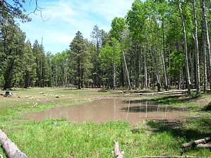
Wildflower Dotted Meadows by HAZ_Hikebot  The Northwest portion of the Blue Range Primitive Area where this trail is located has been severely affected by the Wallow Fire of June 2011. The area is currently open to public use and entry - HOWEVER trails may not have been recently assessed or maintained for hazards associated with the fire, so plan your trip accordingly. The Northwest portion of the Blue Range Primitive Area where this trail is located has been severely affected by the Wallow Fire of June 2011. The area is currently open to public use and entry - HOWEVER trails may not have been recently assessed or maintained for hazards associated with the fire, so plan your trip accordingly.Please keep in mind that any area affected by the wildfire can be prone to hazards such as falling trees, flooding, and burned-out stump holes. The environment you are entering is highly susceptible to rainstorms and wind events. Any time you enter the forest, you should be aware of your environment and changing weather conditions. You are responsible for your own safety! Always look up, look down, and look all around.
Upper Grant Creek Trail is accessible via any one of the above trails, but the shortest route is via Steeple Creek Trail from the Hannagan Meadow Trailhead. A 1.4-mile stroll through stands of tall conifer, alternating with small hidden meadows, brings you to the Upper Grant Trailhead in the middle of one of the larger meadows or ciénegas in the area. From this access point, the trail follows the course of Grant Creek as it drops into a steep, narrow canyon shaded by a canopy of Douglas-fir and aspen. The trail crisscrosses the tumbling brook that steadily increases in volume as it drops toward its confluence with the Blue. This section of the trail is not recommended for horses. Hikers stand an excellent chance of seeing wildlife in this area. In addition to elk and mule deer, black bears are regularly seen grubbing through the blow-downs. If you happen to run across one of these big but shy creatures, the encounter will most likely be brief. Wild bears make a business of keeping a very low profile. At 3.5 miles into the hike, you'll come onto an old cabin and corral site. Recently, some copper moonshining equipment was recovered from this site. Notes: No mechanized vehicles (including mountain bikes) are permitted in Primitive Area. Recommended ONLY for experienced mountain horses or pack trains. Trail Log: 0.0 Trail terminus. Upper Grant Creek Trail leaves Steeple Trail in a small ciénega (wet meadow) about 1.3 miles from Hannagan Trailhead. 2.2 Tributary drainage from the north crosses the trail. Ranchers call it Slide Canyon as a horse needs to slide down it in spots. 3.2 Another tributary drainage from the north. Ranchers call this one Scoot Canyon as a horse needs to scoot down it. 3.5 Moonshiner's cabin and corral. 3.6 Junction with Grant Cabin Trail #306, which connects to Grant Creek Trail #75. 3.8 Junction with Long Cienega Trail #305, which connects to Steeple Trail #73. 4.0 Trail terminus. Junction with Paradise Trail #74. USGS Maps: Hannagan Meadow, Strayhorse Check out the Official Route and Triplogs. Leave No Trace and +Add a Triplog after your hike to support this local community. One-Way Notice This hike is listed as One-Way. When hiking several trails on a single "hike", log it with a generic name that describes the hike. Then link the trails traveled, check out the example. | ||||||||||||||||||||||||||||||||||||||||||||||||||||||||||||||||||||||||||||||||||||||||||||||||||||||||||||||||||||||||||||||||||||||||||||||||||||||||||||||||||||||||||||||||||||||||||||||||||||||||||||||||||


