Coronado National Memorial NPS Details Trail begins at Montezuma Pass. Quotations from the journals of Coronado's captains, posted at scenic overlooks along the trail, provide a glimpse into the minds and hearts of the conquistadors as they trekked northward along the San Pedro River. From Coronado Peak one is overwhelmed by the beauty of the San Pedro and San Rafael Valleys and the panoramic views of the desert grasslands.
WARNING! Hiking and outdoor related sports can be dangerous. Be responsible and prepare for the trip. Study the area you are entering and plan accordingly. Dress for the current and unexpected weather changes. Take plenty of water. Never go alone. Make an itinerary with your plan(s), route(s), destination(s) and expected return time. Give your itinerary to trusted family and/or friends.
Permit $$
no fees or permits reported
if incorrect tell us about it
Coronado Forest MVUMs are rarely necessary to review unless mentioned in the description or directions Coronado Motor Vehicle Use Maps (MVUMs)
Directions
Road
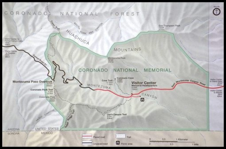
To Montezuma Pass Trailhead Take I-10 east to highway 90 near Benson, AZ. Take 90 south to Sierra Vista (watch your speed on 90 and 92 - lots of speed traps...) Then take highway 92 south to Montezuma Canyon Rd. (just after you descend from the mountains to the west) at the sign for Coronado Nat'l Monument (watch carefully for the sign - the road is easy to miss). Take a right on Montezuma Canyon Rd. and follow it into the park. Keep driving past the end of the pavement and follow the winding, gravel road all the way to the top. Park in the paved lot at the top of the saddle - the trailhead is just across the road from the entrance to the parking lot.
2008-04-05 Update from cleoschyck: From highway 92, the road you will need to take is Coronado Memorial Drive-- take a right just about opposite Valley View Elementary School. A mile or so down Coronado Memorial Drive, the road hooks sharply right. This is the intersection with Montezuma Canyon Road, which you will follow to the paved parking lot at Montezuma Pass. A ramada and composting toilets are available at the parking lot.
From PHX (I-10 & AZ-51) 209 mi, 3 hours 39 mins From TUC (Jct 1-10 & Grant) 100.0 mi, 1 hour 59 mins From FLG (Jct I-17 & I-40) 353 mi, 5 hours 58 mins
 Route Editor


