click tap icons for details
Difficulty
0.5 of 5
Route Finding
1 of 5
Distance One Way
7.4 miles
Trailhead Elevation
6,806 feet
Elevation Gain
407 feet
Accumulated Gain
747 feet
Avg Time One Way
3-4 hours
Kokopelli Seeds
9.89
Dogs not allowed
Inaugural Calculation on Button Tap!
7
2019-01-22
Grand Canyon Rim Trail Loop
markthurman53
5
2017-11-03 BiFrost
14
2017-10-08 topohiker
12
2017-04-15 wallyfrack
4
2017-03-18 arizona_water
12
2016-06-29 fricknaley
12
2016-06-02
Rim-Hermit-Dripping Springs-Waldron
johnlp
15
2016-06-02
Dripping Springs - Grand Canyon
Tortoise_Hiker
Page 1 , 2 , 3
Historical Weather
Trailhead Forecast
Radar
Map - Trails Illustrated Grand Canyon NP
Preferred Apr, May, Sep, Oct → 8 AM
Official Route
1 Alternative
Water
Rim Trail - Hermit's Rest to Village
Official Route
HAZ_Hikebot
7.69 mi 747 ft
Rim Trail - Hermit's Rest to Village
9.73 mi 1,402 ft
Rim Trail - Hermit's Rest to Village
2.41 mi 447 ft
Rim Trail - Hermit's Rest to Village
10.2 mi 1,206 ft
Rim Trail - Hermit's Rest to Village
8.82 mi 842 ft
4 unofficial routes
Grand Canyon Rim Trail Loop
9.82 mi 757 ft
Boucher Rapids via Boucher
0.1 mi away
Boucher Trail
0.1 mi away
Dripping Springs - Grand Canyon
0.1 mi away
Hermit Trail
0.1 mi away
Hermit Creek Campsite to the Colorado River
1.4 mi away
Waldron - Dripping Springs - Silver Bell Loop
1.5 mi away
Cope Butte
1.6 mi away
Waldron Trail
1.7 mi away
Tonto Trail: Hermit Trail to Boucher Trail
1.8 mi away
Monument Creek Trail
1.9 mi away
[ View More! ]
Fauna
Nearby
Arizona Gray Squirrel
Bighorn Sheep
California Condor
Common Raven
Mule Deer
Pinyon Jay
Rock Squirrel
Turkey Vulture
Western Tanager
Meteorology
Nearby
Double Rainbow
Rainbow
Sunset
Virga
Named place
Nearby
Bradley Point
Brahma Temple
Bright Angel Canyon
Bright Angel Point
Buddha Temple
Cape Royal
Cheops Pyramid
Claude Birdseye Point
Clement Powell Butte
Cocopa Point
Colorado River
Columbus Point
Comanche Point
Confucius Temple
Cope Butte
Dana Butte
Demaray Point
Diana Temple
Echo Cliffs
Grand Canyon - South Rim
Grand Canyon National Park
Hattan Butte
Hillers Butte
Horn Creek
Isis Temple
Johnson Point
Jones Point
Lookout Point
Marsh Butte
Mencius Temple
Mohave Point
Mount Trumbull
Ninetyfour Mile Creek
Ninetyone Mile Creek
Osiris Temple
Palisades of the Desert
Pima Point
Plateau Point
Point Sublime
Sagittarius Ridge
Scorpion Ridge
Shinumo Altar
Shiva Temple
Sturdevant Point
Sumner Butte
The Alligator
The Battleship
The Colonnade
The Tipoff
Tower of Set
Trinity Creek
Vermillion Cliffs
Vishnu Temple
Whites Butte
Wotans Throne
Yuma Point
Zoroaster Temple
Culture
Nearby
Benchmark
Cartwheel
Geographic Landmark Labels
Glen Canyon Linear (Zoomorphic)
Headframe
Miscellaneous Survey Marker
Trail Chasers / Whiskers
The Rim Trail leads along the south rim of the canyon about 11.2 miles from Hermits Rest to Pipe Creek Overlook.
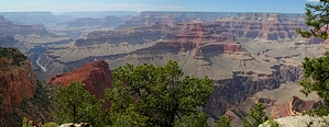
Hermit's Rest to Village 7.4 miHermit's Rest to Pima Point 1.1 mi Pima Point to The Abyss 2.6 mi The Abyss to Mohave Point 1.0 mi Mohave Point to Hopi Point 0.8 mi Hopi Point to Powell Point 0.2 mi Powell Point to Maricopa Point 0.5 mi Maricopa Point to Trailview Overlook 0.7 mi Trailview Overlook to Village 0.5 mi Village to Mather Point 2.5 miVillage to Yavapai Point 1.9 mi Yavapai Point to Mather Point 0.6 mi Mather Point to Pipe Creek Overlook 1.2 miMather Point to Pipe Creek Overlook 1.2 mi
One-Way Notice This hike is listed as One-Way.
When hiking several trails on a single "hike", log it with a generic name that describes the hike. Then link the trails traveled, check out the
example .