Route Editor

| Guide | ♦ | 53 Triplogs | 1 Topic |
details | drive | permit | forecast | 🔥 route |
stats |
photos | triplogs | topic | location |
| 261 | 53 | 1 |
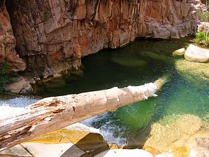
Payson's hidden oasis by joebartels  2012 Notice 2012 NoticeAccess has changed from text below, this hike now starts at Second Water Crossing. History Jesse W. Ellison was a rancher and also a colonel of the Civil War. Ellison was known to herd cattle in the area giving the creek its name. Interesting to mention Ellison's daughter Duette married George W.P. Hunt. Hunt was Arizona's first governor and is entombed at Papago Park along with the Ellison's.
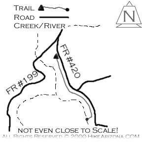
Ellison Creek Cascades is one of Arizona's favorite swimming holes. Personally, it's my favorite. There is no official trail, but rest assured, this area gets used. From Cold Springs Camp Grounds, continue walking past the gate on FR420. Pine covered rolling hills make the views going down the old jeep track. Sure would be nice to live here. At a quarter-mile, the road levels for a short distance and then begins to climb. Keep an eye over your right shoulder. You should be able to hear the cascading water of Ellison Falls. You need to find one of the several trails of use down to the swimming hole. If you come to a fence with a substantial private property sign, you missed the scramble down to the creek. Backtrack about a hundred or more yards and go on down. Be careful as it's steep. Synopsis Unfortunately, the area is trashed, holding par with other Payson recreation sites. The lure is obvious. Ellison Creek cascades down from the private property above. It's close to the valley and easy to access. The water is usually crystal clear, barring a recent rain. Even in a dry year like this has been, it's reliable. Be forewarned it's packed with beer-guzzling party-goers on hot weekends. Go during the week, and it's a lost oasis awaiting your arrival. Gate Policy: If a gate is closed upon arrival, leave it closed after you go through. If it is open, leave it open. Leaving a closed gate open may put cattle in danger. Closing an open gate may cut them off from water. Please be respectful, leave gates as found. The exception is signage on the gate directing you otherwise.
Check out the Official Route and Triplogs. Leave No Trace and +Add a Triplog after your hike to support this local community. | |||||||||||||||||||||||||||||||||||||||||||||||||||||||||||||||||||||||||||||||||||||||||||||||||||||||||||||||||||||||||||||||||||||||||||||||||||||||||||||||||||||||||||||||||||||||||||||||||||