This trail follows one of the earliest known routes to the top of Mt. Lemmon, believed to be the trail that John and Sara Lemmon followed in the early 1880's on their trip to the summit of the mountain which was later named in Sara's honor. This trail is reportedly where biologist Lemmon saw his first Arizona pine. Actually a subspecies or variety of ponderosa pine, this was the first of roughly 100 plant species and subspecies Lemmon cataloged in the state's southern mountains.
In spite of the fact that the Oracle Ridge Trail has been traveled for so long a time, it is quite hard to follow in a number of places, perhaps because it passes through a center of mining and prospecting activity. As a result, old mining roads and bulldozer paths have obscured the trail in several places. If you are a history buff, you'll appreciate the old and not-so-old mines you encounter along this route. If your interests tend toward more natural sights, you'll probably spend more time taking in the views which stretch to the north, east and west. The Oracle Ridge Trail passes very near the summit of Rice Peak and relatively near the summit of Apache Peak. These two peaks offer good views of Mt. Lemmon and the Santa Catalinas, as well as of the historic mining district around the town of Oracle and the basin and range landscape beyond.
Attractions: Ridge top panoramas, North, east, and west views, Pine forest to desert diversity, Historic mining area & Arizona Trail segment.
When hiking several trails on a single "hike", log it with a generic name that describes the hike. Then link the trails traveled, check out the example.
WARNING! Hiking and outdoor related sports can be dangerous. Be responsible and prepare for the trip. Study the area you are entering and plan accordingly. Dress for the current and unexpected weather changes. Take plenty of water. Never go alone. Make an itinerary with your plan(s), route(s), destination(s) and expected return time. Give your itinerary to trusted family and/or friends.
Permit $$
no fees or permits reported
if incorrect tell us about it
Coronado Forest MVUMs are rarely necessary to review unless mentioned in the description or directions Coronado Motor Vehicle Use Maps (MVUMs)
Directions
Road
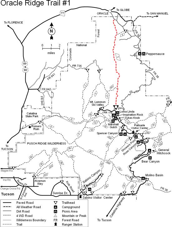
To hike From Tucson: Take the Catalina Highway off Tanque Verde Road. Drive 4.2 miles to the Forest boundary and continue 25 miles to a point past the Loma Linda Picnic Area where the Control Road (FR 38) turns right and passes the Mt. Lemmon Fire Station. Follow this road straight, past the fire station and down the ridge. Just beyond the first cattle guard, the trail leaves from a parking area on the left side of the road and cuts through a notch in the ridge.
From Oracle: Follow the Oracle Highway through the town of Oracle to the Old Mt. Lemmon Road (also called the Control Road and FR 38). Go down the Old Mt. Lemmon Road .2 miles to Cody Loop Road and turn right. Then proceed .7 miles up Cody Loop Road until you see a small turnout on the left below a large water tank. There is enough space to tightly fit in about three cars. From this parking area look across Cody Loop Road into the brush and you can see the trailhead sign poking through the brush.
 Route Editor

 This trail follows one of the earliest known routes to the top of Mt. Lemmon, believed to be the trail that John and Sara Lemmon followed in the early 1880's on their trip to the summit of the mountain which was later named in Sara's honor. This trail is reportedly where biologist Lemmon saw his first Arizona pine. Actually a subspecies or variety of ponderosa pine, this was the first of roughly 100 plant species and subspecies Lemmon cataloged in the state's southern mountains.


