 Route Editor

| Guide | ♦ | 65 Triplogs | 1 Topic |
details | drive | permit | forecast | 🔥 route |
stats |
photos | triplogs | topic | location |
| 457 | 65 | 1 |
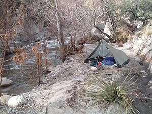
Some water amid the hot & dry! by Vashti   Note NoteAs of March 2011, page stats reflect the entire loop. One thing to mention about this trail: don't do this trail when it's 110F outside!!! There is very little to no shade on this trail due to the fire in the area ~2 years ago. Despite the fire, the desert vegetation is recovering nicely, and the trail is not hard to follow. We did this trail starting from the parking lot at the base of the canyons. We started earlier than the trams started running. We chose to do this loop, starting in Bear Canyon and ending in Sabino Canyon. We did it that way because we had a few in our group that were day hikers only going to Seven Falls and back. The beginning of this trail follows the same trail as described for Seven Falls. In 20/20 hindsight, it would be better to start at Sabino Canyon and end in Bear Canyon to gain some shade by the mountains!!
Something to mention about the hike thus far; it is not for those who wish for solitude. The hike up to Seven Falls is very crowded. We saw many people and groups coming and going, including the requisite loud group of young boys thoroughly enjoying themselves by swimming and jumping around the pools at Seven Falls. After stocking up on water at Seven Falls, we continued up Bear Canyon Trail #29 on our way to Sabino Canyon. The trail is relatively easy to follow, but some confusion may result from the plethora of spur trails surrounding the Seven Falls area. The key is to follow the trail which leads away from Seven Falls and up the canyon. After leaving the crowded part of Bear Canyon, we saw no one on the trail. The trail continues to ascend for ~4 miles. The incline is not unbearable, but the last mile or so was rough given the excessive heat. The scenery along the way was beautiful as you continue hiking above and on the western bank of the drainage. There appeared to be quite a few nice swimming holes from what we could see, complete with gently rushing waterfalls! Midway to the saddle, you cross the creek. The water stains the surrounding rock red, leading me to believe that some minerals are present. Eventually, after several switchbacks, you reach the saddle and continue east to meet the East Fork trail (#24A) junction. The mileage from the end of the Bear Canyon shuttle bus road to East Fork is ~6.5 miles. The East Fork junction is signed, and we continued on our way to Sabino Canyon. From the saddle continuing east, you eventually lose a good bit of the elevation you just climbed. There are a few long switchbacks that put you into a drainage. There are some trees here, and we stopped to rest in the relatively rare shade. Continuing east, you eventually come upon the signed trail junction for Box Canyon. Very shortly thereafter is the signed junction for Sabino Canyon. Ironically, the sign is very low to the ground, and it could be possible to miss it if you weren't looking for it. Regardless, the trail is very well maintained and very easy to follow, so there should be no danger in getting lost as long as you know where you are supposed to be going! The trail for Sabino Canyon (#23) heads back uphill to the South. At this point, we were very concerned about our dwindling water supply, even though we were relatively close to the tram stop (~2.5 miles away). It's amazing how the beating sun and excessive temperatures can sap your energy! :O The trail becomes rockier and exposed due to lack of vegetation. Our trip ended at the last tram stop, at which there is a signed junction leading to 0.5 miles worth of steeply descending switchbacks. Given the intense heat, we were delighted to see the tram. It is worth mentioning that the tram is insanely expensive, ~$8 per person. Nevertheless, we rode the tram back to the parking lot, saving ourselves ~3 miles of walking in the unforgiving sun. If you so desire, you can walk the remaining 3 miles back to the parking lot on the Phone Line Trail #27. While hiking from the East Fork Trail to the tram stop on the Sabino Canyon trail, we saw two additional solo hikers. I imagine we would have seen more except for the temperature. Overall, the hike was beautiful, and the solitude (beyond Seven Falls) was lovely, despite the roasting heat. We recommend this hike, but not during scorching temperatures. We were exceedingly lucky that we didn't run out of water (and we had a lot to start with, but it goes fast!!!). One other misfortunate regarding this hike: we forgot our camera, so we have not one image to share! :(
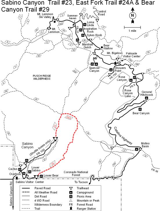
Coronado FS Details Sabino Canyon Trail (FS #23), East Fork Trail (FS #24) and Bear Canyon Trail (FS #29) These three trails offer access to the dramatic landscape of the Santa Catalina Front Range, famous for its deep canyons and soaring ridges. When traveled as a loop, they form a long but rewarding day-trip that offers memorable views and access to the riparian environments they shelter. A trip along either trail or around the entire loop will treat you to good views of the high ridges and peaks of the Front Range and, at sunset, of the city of Tucson with its lights framed by the black silhouette of surrounding mountains. Since both Bear Canyon and Sabino Canyon trails are accessible from the extremely popular Sabino Canyon Recreation Area, both are used heavily. Sabino Canyon Trail begins at the end of the recreation area shuttle bus route and contours along the canyon's eastern slope a good distance above the canyon floor. A number of paths branch off the trail along this stretch and lead down to the streambed. Bear Canyon Trail leads upstream from the Lower Bear Picnic Area at the end of the Bear Canyon shuttle route. The trail crosses the stream several times in its first two miles and provides spectacular views of both Sabino and Bear canyons as it climbs to Bear Saddle. There it intersects the East Fork #24A and the Sycamore Reservoir #39 trails. The East Fork Trail follows Sabino Creek 2.1 miles to the junction with Sabino Canyon Trail. From this point it is 2.5 miles back to the end of the road where hikers can catch a shuttle bus ride (for a fee) or walk back to their car to complete a 13.4 mile loop. Since horses are not permitted on the shuttle road, equestrians must use the Phone Line Trail #27 (4.5 miles) to complete a loop. Attractions: Spectacular canyon Lush desert Long distance views Backcountry access Loop possibilities Trail #24A is a segment of the Arizona Trail Check out the Official Route and Triplogs. Leave No Trace and +Add a Triplog after your hike to support this local community. | ||||||||||||||||||||||||||||||||||||||||||||||||||||||||||||||||||||||||||||||||||||||||||||||||||||||||||||


