 Route Editor

| Guide | ♦ | 70 Triplogs | 3 Topics |
details | drive | permit | forecast | 🔥 route |
stats |
photos | triplogs | topics | location |
| 261 | 70 | 3 |
Here's to good friends by fricknaley   I am a big fan of the Rincons here in Tucson. They are very isolated and expansive, though located so close to the city. The hikes here tend to be long, fairly difficult, and always worth the effort. The Miller Creek trail out of Happy Valley on the east side of the range is a perfect example. This is a section of the Arizona Trail as well and partly lies within the Saguaro East district. I am a big fan of the Rincons here in Tucson. They are very isolated and expansive, though located so close to the city. The hikes here tend to be long, fairly difficult, and always worth the effort. The Miller Creek trail out of Happy Valley on the east side of the range is a perfect example. This is a section of the Arizona Trail as well and partly lies within the Saguaro East district.From the parking area immediately pass through a gate and travel along fairly level ground as you start to enter the canyon. You parallel the wash which usually has running water. This is Happy Valley and it is a well-kept secret in my opinion, as the area is full of vegetation, wildlife, and running water. This is not your typical Sonoran desert. Follow the trail, which crosses the stream several times, and after about 3/4 mile or so the trail climbs out of the wash and starts heading right and climbing across the land towards the Rincon foothills.
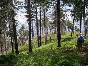
From here the trail basically turns left and starts heading up Miller Canyon. All of a sudden you are in a lush forest and water can often be heard running down the canyon. This part of the hike takes on a very different feel from the beginning and was my favorite part. You keep on climbing to the left of the canyon until the trail basically breaks left, winds, and climbs a bit more before dropping you off at the Happy Valley Saddle, where the trail ends into the Heartbreak Ridge Trail. This puts you at roughly 4.4 miles and about 2000 feet in elevation. This is the turnaround point for this hike...but there are other options from here if you are not quite ready to call it quits. To your left (south) lies the way to Rincon peak. To the right (north) you can follow the Heartbreak Ridge trail ultimately to Manning Camp. I admit I did take that right and continued for about 45 minutes or so. If you so choose read on, if not head back home. The trail soon climbs through some rocky slopes, winds around and deposits you on the western face of the Rincons. As you climb through nicely recovering forest spectacular views of the western Rincons, Tucson, and to the south Rincon Peak present themselves to you. Placated by this outrageous scenery I decided to call it a day, turn around, and head back home. The stats in the heading above are to the saddle. I continued for about 1-1.25 miles and added great scenery and more elevation gain to my hike, making the total distance for me about 11 to 11.5 miles or so. Gate Policy: If a gate is closed upon arrival, leave it closed after you go through. If it is open, leave it open. Leaving a closed gate open may put cattle in danger. Closing an open gate may cut them off from water. Please be respectful, leave gates as found. The exception is signage on the gate directing you otherwise.
Coronado FS Details This Rincon Mountain Wilderness trail provides access into the Saguaro National Park and, when combined with the Rincon Peak Trail, serves as the shortest route to the summit of that 8,482 foot mountain. The first 1.5 miles of the route are located in the Coronado National Forest, following Miller Creek for about half that distance. This small stream and the riparian habitat it supports combine to provide a pleasant setting for those here to just spend time bird watching or enjoying the picturesque surroundings. Those passing through headed for destinations more distant will most likely appreciate them as well. In order to protect this pleasant but fragile environment it is being managed for low-impact recreation, so no horseback riding or mountain biking is permitted on this trail. After following the creek for a little over three quarters of a mile, the trail climbs along the canyon's north ridge and enters the National Park bound for its junction with the Rincon Peak Trail. The Miller Creek Trail is a part of the Arizona Trail system. Attractions: Desert riparian area Access to Saguaro National Park Arizona Trail segment Access to Rincon Peak Saguaro National Park restrictions: No hunting, weapons, pets or bicycles. Camping in designated areas only. Must have a wilderness permit which is available at the Park Visitor Center. Check out the Official Route and Triplogs. Leave No Trace and +Add a Triplog after your hike to support this local community. One-Way Notice This hike is listed as One-Way. When hiking several trails on a single "hike", log it with a generic name that describes the hike. Then link the trails traveled, check out the example. | |||||||||||||||||||||||||||||||||||||||||||||||||||||||||||||||||||||||||||||||||||||||||||||||||||||||||||||||||||||||||||||||||||||||||||||||||||||||||||||||||||||||||||||||||||||||||||||||||||||||||||||||||||


