 Route Editor

| Guide | ♦ | 106 Triplogs | 2 Topics |
details | drive | permit | forecast | 🔥 route |
stats |
photos | triplogs | topics | location |
| 763 | 106 | 2 |
Partial old track by fricknaley   This hike totally exceeded my expectations. The views are awesome and the area around the reservoir is a great out of nowhere riparian hangout. Be warned that this hike goes through some of the most densely burned areas of the Aspen fire. But the recovery is in full effect and many areas were skipped...the Catalinas are recovering. This is also a segment of the Arizona Trail, which I did not know at first. This hike totally exceeded my expectations. The views are awesome and the area around the reservoir is a great out of nowhere riparian hangout. Be warned that this hike goes through some of the most densely burned areas of the Aspen fire. But the recovery is in full effect and many areas were skipped...the Catalinas are recovering. This is also a segment of the Arizona Trail, which I did not know at first.Begin by hiking out of the parking area in the back of the old Prison Camp campground. You immediately come to an intersection with Molino Trail and a sign informing you the Sycamore Canyon/Reservoir trail is to be found to your right. So hang a right and continue along an old jeep track and into the remains of the old prison sites... all that's left are the cement foundations. Soon enough another sign says the Molino trail continues off to your left and the Sycamore Reservoir trail marches on straight ahead.
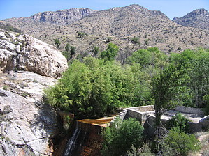
After about a mile or so you slowly build up to a saddle, where you can see a big sign officially proclaiming the Arizona Trail. Let me tell you, the view on the other side of that saddle blew my mind like rarely before. This is a knock-out worthy of a few pictures for sure. The Sycamore Reservoir Trail breaks off to the left (signed) and begins to wander slowly down the left ridge of Sycamore Canyon. Magnificent views lead the way slowly down. Eventually, you hit ground level, cross over the wash and continue down the right side of the canyon. Now you can see the dense stand of brilliant greenery in the area about the reservoir. You hit the bottom and a sign says it's a mile back to the parking area (uh...need to update that sign folks). Anyway explore around here and enjoy this fantastic area of shade and water. A short spur trail to your left leads around the concrete dam, which looks pretty cool with the falls running down it. Back at the sign, the main segment breaks off to the right. You can hang out here and turn back, or continue on the trail which reflects the trail data listed on this page. It's another mile before joining the West Fork Trail as the Arizona Trail continues. I followed it for about 30 minutes just to add a little distance. In the bottom of the corridor, look for a series of cairns to show you the way the trail continues (it's to your left). This is the only part of the trail where you may briefly lose the route but if you are not on a narrow, clear trail back up and find the cairns.
Coronado FS Details Sycamore Reservoir was originally constructed to supply water to an old federal prison camp along the Catalina Highway. Since 1992, this small lake has been almost completely silted in, creating a small marshy riparian area. Still, the area remains a pleasant destination for a day trip or an overnight stay. A sand beach and stands of alder, willow and sycamore grace various parts of its shoreline. Riparian vegetation extends into the two canyons that come together to form the dam site, providing habitat for birds and other wildlife. The trail to the reservoir starts in an area occupied by the ruins of an old prison camp -- now the Gordon Hirabayashi Recreation Site. Concrete foundations are all that remain of the buildings that once stood here, and a 4-wheel drive road now winds its way through the ruins to a trailhead at the Pusch Ridge Wilderness boundary. The road through the prison camp is closed seasonally, which adds about a mile and a quarter to the trip. If the gate is open, you will want to drive only part way to the trailhead, unless you have a 4-wheel drive vehicle with high clearance. 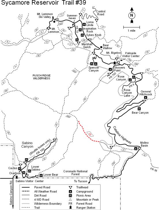 At the Wilderness boundary, the trailhead is just south of the gate, and parallels an abandoned road as it heads downhill toward the reservoir. In 1991, the Forest Service attempted to obliterate the old roadbed to reduce soil erosion and to restore a more natural condition; however, some hikers and equestrians continue to use the old road, creating an unmaintained social trail that prevents vegetation from re-establishing. So, please avoid using this social trail and stick to the actual trail on the south side of the drainage. Also, for the same reasons, please avoid the unmarked spurs which occasionally branch off the main trail. By staying on the trail, you'll help the area recover to a healthier condition. At the Wilderness boundary, the trailhead is just south of the gate, and parallels an abandoned road as it heads downhill toward the reservoir. In 1991, the Forest Service attempted to obliterate the old roadbed to reduce soil erosion and to restore a more natural condition; however, some hikers and equestrians continue to use the old road, creating an unmaintained social trail that prevents vegetation from re-establishing. So, please avoid using this social trail and stick to the actual trail on the south side of the drainage. Also, for the same reasons, please avoid the unmarked spurs which occasionally branch off the main trail. By staying on the trail, you'll help the area recover to a healthier condition.At the point where the trail enters Sycamore Canyon, it shares a portion of its course with an old fire line bulldozed to stop a chaparral fire some time ago. Again, if you stay on the main trail, all of these unsightly scars will heal naturally. Attractions: Riparian area Wildlife Connecting trails Arizona Trail segment Check out the Official Route and Triplogs. Leave No Trace and +Add a Triplog after your hike to support this local community. One-Way Notice This hike is listed as One-Way. When hiking several trails on a single "hike", log it with a generic name that describes the hike. Then link the trails traveled, check out the example. | |||||||||||||||||||||||||||||||||||||||||||||||||||||||||||||||||||||||||||||||||||||||||||||||||||||||||||||||||||||||||||||||||||||||||||||||||||||||||||||||||||||||||||||||||||||||||||||||||||||||||||||||||||


